
Ridge Shows Signs of Weakness
High Pressure Ridge Offers Mixed Conditions, Midwest Showers Later
One reason, among many, that long-range forecasts can lead us to wrong conclusions is their lack of subtlety. One single weather forecast or model run tends to behave erratically each time it is run, especially far out into the future. It can be really amazing the weird things that models try to do when their equations are left to continue far out in time. But if we take a lot of simulations together, creating an ensemble, averaging the chaos can give us clues as to the weather we can expect beyond the next week.
Ensemble forecasts are an incredibly useful tool in the meteorologist's toolkit instead of looking at a bunch of weather models individually that do not seem to have a pattern in themselves. But ensembles are just one tool and they have limitations. The largest limitation is related to their greatest strength -- the averaging. While smoothing out the models lets us eliminate the chaos, we lose the subtlety that so often occurs in the atmosphere. Small disturbances can be washed out to look like nothing, or their effect can be hard to see and understand. And it is often these subtle features that lead to dramatic weather events.
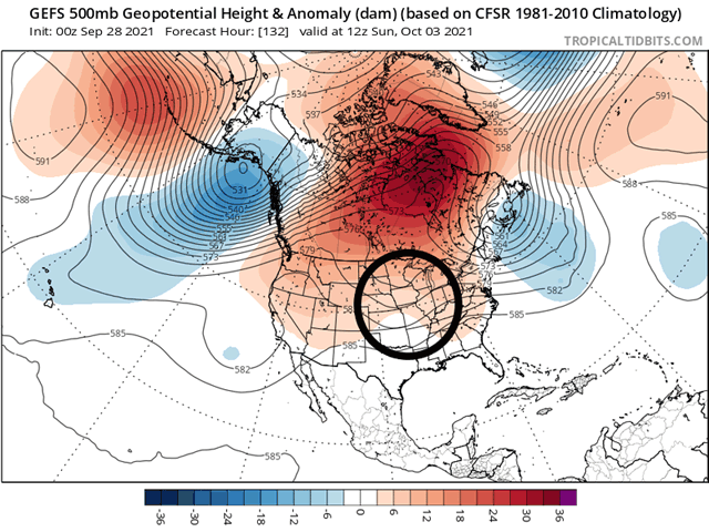
Enter then this week, as a large dome of high pressure is forming across the middle of North America. Last week, it appeared this ridge was going to be so strong as to block a storm developing across the West Coast from advancing into the Plains, keeping the region and points eastward hot and dry with great harvest conditions while sapping soil moisture for winter wheat. So far this week, that has been the case as temperatures have reached into the 90s Fahrenheit across the Plains and in the 70s and 80s elsewhere, well above normal for this time of year.
P[L1] D[0x0] M[300x250] OOP[F] ADUNIT[] T[]
But what I missed in the ensembles last week was a weakness over the U.S. that could allow for western systems to move underneath the strong portion of the ridge over Hudson Bay. That weakness now looks to provide for some scattered showers across the Plains for the next several days and, while it slowly pushes through the ridge, will spread showers through the Midwest and Delta regions as well later this week and weekend.
Producers have seen some pretty good harvest conditions recently for most areas outside of a storm system last week that made for heavy rain across the Eastern Corn Belt. As of Monday's report from USDA, corn harvest has increased to 18% complete, while soybeans have advanced to 16% complete, both three percentage points ahead of the five-year average. Double-digit progress from the previous week was noted in a smattering of states across the country, though not in the states of Indiana, Michigan, or Ohio, where the heavy rain occurred.
Planting progress for winter wheat has also been mostly unencumbered, though dryness across the Southern Plains has been concerning and perhaps limited more substantial progress. Still, Nebraska, Kansas, Oklahoma and Texas are all sitting right at or slightly ahead of their average planting progress to this date and awaiting the rains this week to help with germination and establishment.
Drought has been expanding over the last couple of weeks from Nebraska southward in the Plains, but daily scattered showers from Sept. 29 to at least Oct. 2 should help to reverse some of that drought, or at least halt it from expanding farther. Models have varied solutions on how widespread and heavy rain will be in these areas, but at least an inch looks likely for most areas with heavy amounts over three inches possible where clusters of storms are more consistent and repeated. The rains could slow down harvest progress for sure, but the drought reduction and winter wheat impacts will be more important.
Back up in the Corn Belt, showers will be very slow to move eastward through the region starting on Sept. 30. Models are insistent that, at some point, scattered showers will make it into and through the Midwest. But they differ on timing, scope, intensity and length, leading to all sorts of uncertainty about how this will ultimately affect harvest progress. But there could and should be at least some delays in a few areas when the showers finally do come through. But until then, harvest conditions should be very good, as we anticipated last week.
John Baranick can be reached at john.baranick@dtn.com
(c) Copyright 2021 DTN, LLC. All rights reserved.