
Continued Drought for North-Central US
Outlook Points to Persistent Drought With Widespread Effects
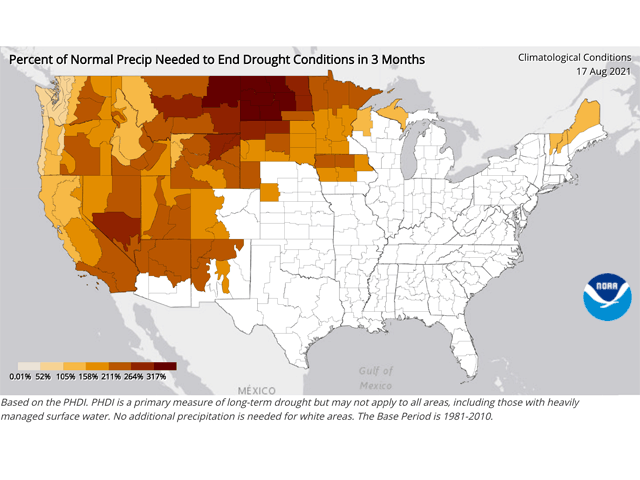
The latest NOAA north-central region drought status update has some daunting statistics: More than half -- 52% -- of the central U.S. is in drought; 24% of the central U.S. is in either extreme (D3) or exceptional (D4) drought; it has been 9.5 years, since 2012, since drought has covered this extensive an area of the central United States.
The north-central U.S. is made up of the entire states of Illinois, Indiana, Iowa, Kansas, Kentucky, Michigan, Minnesota, Missouri, Montana, Nebraska, North Dakota, Ohio, South Dakota, Wisconsin, and Wyoming; and the Missouri River Basin portion of Colorado.
Of these states, 100% of Montana and North Dakota are in drought; 97% of Minnesota; 95% of Wyoming; 94% of South Dakota; and 57% of Iowa. Also, recent notable rainfall has not moved the drought needle; the report notes that the severity and extent of drought are "virtually unchanged," according to the U.S. Drought Monitor.
P[L1] D[0x0] M[300x250] OOP[F] ADUNIT[] T[]
Effects of the drought are widespread in the region. These include wildfires; limited surface water in streams, rivers and livestock ponds; poor water quality; disruption to recreation; low soil moisture; poor pasture conditions; crop yield loss; rural mental health issues; and damage to ecosystems.
Yes, there has been rain recently, and more rain is forecast into early September. But the report stresses: "Given the severity of the current drought, consecutive seasons with above-normal rain and snow events will be needed in order to see improvement in drought impacts. As a result, drought conditions will likely persist into next year, although some improvement might be possible."
Northern Iowa, southern Minnesota and southern Wisconsin possibly will see the highest chance at drought easing. These areas had rainfall in the week of Aug. 23-29, totaling from 2 to 5 inches and even heavier in northeast Iowa; river and stream flooding resulted. However, severe to extreme drought in effect means that long-term drought easing may be minimal.
In addition, conditions continued to be very warm to hot during this late-August period. Daytime temperatures were noted in the 90s Fahrenheit and overnight low temperatures in the 70s -- with some new record-warm minimums posted.
The north-central drought status update is a collaboration of the NOAA/National Integrated Drought Information System (NIDIS), the USDA Midwest and Northern Plains Climate Hub and the NOAA/National Centers for Environmental Information.
The full report is available here: https://www.drought.gov/….
Bryce Anderson can be reached at Bryce.anderson@dtn.com
Follow him on Twitter @BAndersonDTN
(c) Copyright 2021 DTN, LLC. All rights reserved.