
Strong Hurricane Ida Poses Crop Threat
Hurricane Ida Makes Landfall, Path Still Aims for Delta Cotton, Soybeans
Editor's Note: This article was updated Aug. 29 at 3:48 p.m. CDT from its original Aug. 27 posting.
**
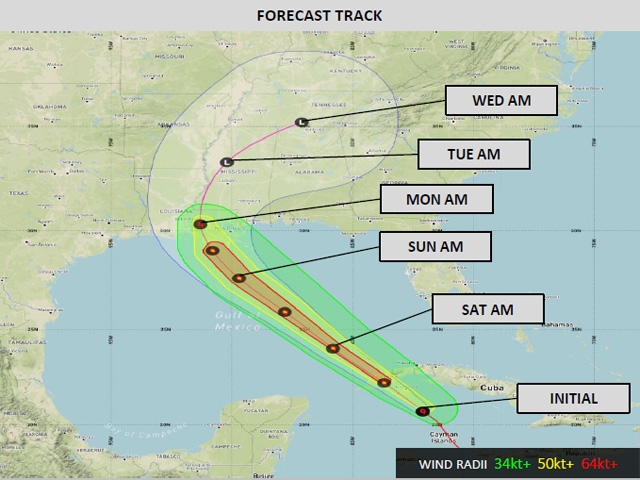
Hurricane Ida made landfall near Port Fourchon, Louisiana at 11:55 a.m. on Aug. 29, 2021 as a strong Category 4 hurricane with maximum sustained wind speeds at landfall of 150 mph.
The track of the storm has only changed slightly from this article written on Aug. 27, with the major changes about a more gradual turn to the east.
(To see daily video updates from DTN meteorologists and follow the track on Ida, go to www.dtn.com/hurricane-ida.)
Heavy rainfall and flooding continue to be concerns for crops and livestock in the Delta and Alabama as the system passes through during the next couple of days.
Ida's remnants should pass through the Tennessee Valley on Tuesday, then go through the Mid-Atlantic and Northeast on Wednesday and Thursday, respectively.
Outside of where the hurricane hit along the coast and rain could reach a foot or more, widespread heavy rainfall of 3 to 6 inches is expected close to the center of the storm, including for the southern half of the Delta region. Tornadoes are also a threat, though wind damage should be minimal and the worst is focused across Louisiana and southern Mississippi.
Prior to the arrival of Ida, the cotton crop was considered in really good shape this year across the Delta and Southeast, with its highest rating in five years.
However, Ida was threatening flood and wind damage in that area from Sunday afternoon into Tuesday.
SYSTEM INTENSIFIED QUICKLY
IDA was noted for how quickly the system intensified. In the nine hours prior to early afternoon Friday, it went from maximum sustained winds of 45 miles per hour at 4 a.m. CDT to 75 mph, a became a Category 1 hurricane.
It crossed the western tip of Cuba late Friday, then moved into the Gulf of Mexico by Friday night. Overnight from Saturday into Sunday, within a few hours, it quickly moved from a Category 2 to a Category 4 hurricane by shortly after 4 a.m. CDT.
Gov. John Del Edwards pointed out at a news conference Sunday afternoon that Ida is "one of the strongest to make landfall in modern times." He said the "extremely strong" Category 4 doesn't make much difference from if it would have been a Category 5 hurricane. The sustained 150 mph at landfall was just short of the 157 mph or higher that would have made it a Category 5 hurricane.
The governor announced he has activated the entire Louisiana National Guard of 4900 members to help deal with the impact of the hurricane.
P[L1] D[0x0] M[300x250] OOP[F] ADUNIT[] T[]
President Joe Biden also announced he had signed emergency declarations for Louisiana and Mississippi to trigger full federal resources to help the region. "The storm is a life-threatening storm," he emphasized during a news conference.
LIVESTOCK MOVEMENT AFFECTED BY STORM
On Saturday evening, Louisiana's agriculture department announced ag departments from several other states would waive their health certificate requirements for livestock coming into their states because of Ida.
Mississippi, South Carolina, Florida and Tennessee authorized temporary waivers until Sept. 17, although Mississippi, Florida and South Carolina would still require proof of Equine Infections Anemia tests. More on the waivers could be found at https://www.ldaf.state.la.us/….
TRANSPORTATION EMERGENCY DECLARATION
The Federal Motor Carrier Safety Administration (FMCSA) earlier today issued an Emergency Declaration in response to Hurricane Ida, effective until Sept. 28. The Emergency Declaration provides regulatory relief for commercial motor vehicle operations while providing direct assistance supporting emergency relief efforts transporting supplies, goods, equipment, and fuel into the Affected States related to Hurricane Ida.
Included in this Emergency Declaration are: Alabama, Arkansas, Louisiana, Mississippi, Tennessee and Texas.
FMCSA said it intends to continually review the status of this Emergency Declaration and may take action to modify or terminate the Emergency Declaration sooner if conditions warrant. Here is a link to more information: https://www.fmcsa.dot.gov/….
CONDITION OF COTTON CROP BEFORE STORM
A week ago, USDA reported how good crops were in the area.
According to the USDA NASS data released Aug. 23, the good-to-excellent rating of 71% for the cotton crop is the highest rating in the past five years. All states in the Delta and Southeast have at least a 70% rating except for Tennessee, which is at 67%.
Soybeans in the Delta are also doing quite well. Good-to-excellent ratings for each of the states sits at or above 69%, well-above the overall average of 56% across the country.
Rainfall has been plentiful this year even before Ida. Outside of some small patches of dryness that have shown up in the Delta during the last couple of weeks, consistent rainfall has led to good crop stands across both the Delta and Southeast.
The rain has also had a small negative effect, as development has fallen short of normal. The percentage of cotton that has set bolls is only at 79% nationally, compared to 89% on average, with many of these states a few ticks behind the average pace. The percentage of crop with open bolls stands at 14% nationally compared to 19% on average.
Most of the states in the Delta and Southeast are falling a few ticks short of average. The only state outpacing either of these is Mississippi. A similar situation is found in soybeans, where crop progress on soybeans setting pods is a few percentage points behind the average pace outside of Mississippi. Very little of the crop has dropped leaves, but that process is starting up across the Southern U.S.
VULNERABLE CROPS
With much of the crop entering maturity, the crop also becomes vulnerable to yield losses due to severe weather.
With plants dying, they show little ability to correct themselves should a severe weather event like strong winds or flooding occur. Strong winds can knock over plants and make them difficult to harvest. Some stripping of pods and bolls may occur. With flooding, pods and bolls can be stripped of the stem or plants can be uprooted and washed away. Depending on soil texture and subsequent rainfall, fields with flood damage may take weeks to get back to workable for equipment, causing more delays in harvest and keeping the door open for adverse weather to move through the field.
CONDITIONS WERE FAVORABLE FOR STORM
Conditions were favorable for rapid hurricane development. Wind shear, which tears apart thunderstorms and does not allow them to remain focused in a single area, was decreasing around the storm, keeping thunderstorms near the center of the storm. The environment around Ida and its path was moist, keeping the storm from drying out.
And water conditions in the Gulf of Mexico are warm enough to bathe in, between 29 and 31 Celsius (84 to 88 Fahrenheit). The general rule is that temperatures need to be above 26 C (79 F) to support tropical storm development. Temperatures above 29 C (84 F) allow rapid growth and intensification. That continued through the weekend as the storm moved northwest.
By Sunday afternoon, the system made its landfall on Louisiana the coast, and Louisiana's governor said it was the worst to hit the state in 150 years.
Ida is starting to slow down and will move northward up the Mississippi River through Tuesday before turning eastward and moving through the Tennessee Valley and the northern portions of the Southeast or southern Mid-Atlantic.
While winds could be damaging in Louisiana and southern Mississippi, it will be the rainfall that will be the focus for agriculture.
Rainfall amounts of 8 to 14 inches are likely across southern Louisiana near landfall, with gradually decreasing amounts as the system moves farther inland. Still, the southern half of the Delta is likely to experience rainfall of 3 to 6 inches and possibly higher.
Open cotton bolls and desiccating soybeans will run the risk of flood damage.
How far north the damage goes depends on when the system makes a turn to the east. That has to do with one of the fronts moving through the Midwest this weekend into early Monday. The farther that front pushes south, the quicker the remnants of Ida will move east, and the less damage it will do to the Delta region. Models are currently unsure of how far south to push the front, causing some more uncertainty in the track of the storm once it makes landfall.
Cotton in Alabama may endure some flood risk from storm surge that is close to the coast, but farther inland and through Georgia, the current track brings minimal impacts with some risk of moderate rain as the system passes by to the west and north early next week. Through the Carolinas and Virginia, however, flooding risks increase and could be significant for cotton and other crops in the region.
John Baranick can be reached at john.baranick@dtn.com
Elaine Shein and Mary Kennedy also contributed to this story.
(c) Copyright 2021 DTN, LLC. All rights reserved.