
Hurricane Ida Potential Crop Damage
Hurricane Ida Poses Risk to Soybeans, Cotton in the Delta
Editor's Note: This article was updated 6:35 p.m. on Aug. 27 with a link for more information on Hurricane Ida.
**
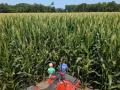
The cotton crop is in really good shape this year across the Delta and Southeast, with its highest rating in five years.
However, Hurricane Ida is threatening to become a major hurricane that could threaten flood and wind damage in that area by Sunday afternoon into Tuesday.
(To see daily updates from DTN meteorologists and follow the track on Ida, go to www.dtn.com/hurricane-ida)
First, a look at the current crop situation in the area that could potentially be hit.
According to the USDA NASS data, the good-to-excellent rating of 71% for the cotton crop is the highest rating in the past five years. All states in the Delta and Southeast have at least a 70% rating except for Tennessee, which is at 67%.
P[L1] D[0x0] M[300x250] OOP[F] ADUNIT[] T[]
Soybeans in the Delta are also doing quite well. Good-to-excellent ratings for each of the states sits at or above 69%, well-above the overall average of 56% across the country.
Rainfall has been fairly plentiful this year. Outside of some small patches of dryness that have shown up in the Delta over the last couple of weeks, consistent rainfall has led to good crop stands across both the Delta and Southeast.
The rain has also had a small negative effect, as development has fallen short of normal. The percentage of cotton that has set bolls is only at 79% nationally, compared to 89% on average, with many of these states a few ticks behind the average pace. The percentage of crop with open bolls stands at 14% nationally compared to 19% on average.
Again, most of the states in the Delta and Southeast are falling a few ticks short of average. The only state outpacing either of these is Mississippi. A similar situation is found in soybeans, where crop progress on soybeans setting pods is a few percentage points behind the average pace outside of Mississippi. Very little of the crop has dropped leaves, but that process is starting up across the Southern U.S.
With much of the crop entering maturity, the crop also becomes vulnerable to yield losses due to severe weather.
With plants dying, they show little ability to correct themselves should a severe weather event like strong winds or flooding occur. Strong winds can knock over plants and make them difficult to harvest. Some stripping of pods and bolls may occur. With flooding, pods and bolls can be stripped of the stem or plants can be uprooted and washed away. Depending on soil texture and subsequent rainfall, fields with flood damage may take weeks to get back to workable for equipment, causing more delays in harvest and keeping the door open for adverse weather to move through the field.
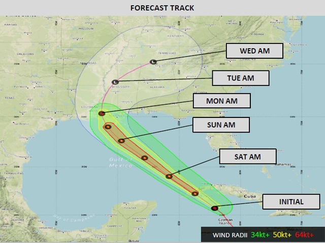
Enter Hurricane Ida. As of 1:15 p.m. CDT Aug. 27, Ida was located about 165 miles east-southeast of the western tip of Cuba. The system has intensified rapidly during the last nine hours, going from maximum sustained winds of 45 miles per hour at 4 a.m. CDT to now 75 mph, a Category 1 hurricane. Ida is forecast to cross the western tip of Cuba later Friday and could briefly go through some weakening. Ida will then move into the Gulf of Mexico by Friday night.
Conditions will be increasingly favorable for rapid development. Wind shear, which tears apart thunderstorms and does not allow them to remain focused in a single area, is decreasing around the storm, keeping thunderstorms near the center of the storm. The environment around Ida and its path is moist, keeping the storm from drying out. And water conditions in the Gulf of Mexico are warm enough to bathe in, between 29 and 31 Celsius (84 to 88 Fahrenheit). The general rule is that temperatures need to be above 26 C (79 F) to support tropical storm development. Temperatures above 29 C (84 F) allow rapid growth and intensification. That is expected through the weekend as the storm continues to move northwest.
By Sunday afternoon, the system is expected to be close to the Louisiana coast, potentially as a strong Category 3, or major hurricane. Ida should then slow down and move northward up the Mississippi River through Tuesday before turning eastward and moving through the Tennessee Valley and the northern portions of the Southeast or southern Mid-Atlantic.
While winds could be damaging in Louisiana and southern Mississippi, it will be the rainfall that will be the focus for agriculture.
Rainfall amounts of 8 to 14 inches are likely across southern Louisiana near landfall, with gradually decreasing amounts as the system moves farther inland. Still, the southern half of the Delta is likely to experience rainfall of 3 to 6 inches and possibly higher.
Open cotton bolls and desiccating soybeans will run the risk of flood damage.
How far north the damage goes depends on when the system makes a turn to the east. That has to do with one of the fronts moving through the Midwest this weekend into early Monday. The farther that front pushes south, the quicker the remnants of Ida will move east, and the less damage it will do to the Delta region. Models are currently unsure of how far south to push the front, causing some more uncertainty in the track of the storm once it makes landfall.
Cotton in Alabama may endure some flood risk from storm surge that is close to the coast, but farther inland and through Georgia, the current track brings minimal impacts with some risk of moderate rain as the system passes by to the west and north early next week. Through the Carolinas and Virginia, however, flooding risks increase and could be significant for cotton and other crops in the region.
John Baranick can be reached at john.baranick@dtn.com
(c) Copyright 2021 DTN, LLC. All rights reserved.