

Ag Weather Forum
Brief Weather Pattern Change for US, Canada
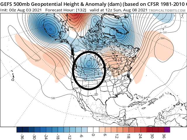
The wall is finally going to open a window. The blocking ridge that has been so consistent across western North America since early June has shown only a couple of weaknesses over the last two months. This time, it will finally give way to a pair of systems that will move through the western half of the continent. One is currently located in the Gulf of Alaska, the other in the eastern Pacific. Both will move into the Pacific Northwest and western Canada Aug. 5-6 and open the door for a couple more disturbances to follow in their wake into the middle of next week.
This is a marked change to the pattern, but it will be brief. Models are suggesting the western ridge redevelops late next week or weekend, shutting the window for any significant and widespread rainfall into the Northern Plains, an area that continues to remain in a terrible drought.
With systems moving through the Northern Plains in rapid succession over the course of five or six days, there are some good chances for rainfall to pile up. That may or may not happen, however. Moisture for the systems may be somewhat limited. The flow from the Gulf of Mexico will not reach the Northern Plains but will remain mostly across the Central Plains and Midwest. The systems that move through will have to work with their Pacific moisture for the most part. Cooler waters over the Pacific do not evaporate as readily as the warmer Gulf of Mexico waters, providing less overall moisture. As the systems move through the western mountain ranges, they'll lose a bit of moisture as well. But the setup will provide ample lift in the atmosphere to produce some scattered showers.
P[L1] D[0x0] M[300x250] OOP[F] ADUNIT[] T[]
Models are currently pegging much of this to occur in Canada. But fronts with strong atmospheric lift should outperform model suggestions across the Dakotas and into the Upper Midwest. The coverage might not be enough to get everyone in the region a good drink of water for thirsty corn and soybeans, but several rounds over the course of five or six days will give everyone a good chance. Minnesota and Iowa may turn out to have the best rainfall stateside, an area that has been dealing with the drought all season long. While Iowa has gotten in on some good rainfall chances over the last month, it has been harder to find them in Minnesota.
Good chances for rain have also been rare this summer in the Northern Plains. Despite several systems that have moved through, atmospheric conditions have been very weak and moisture has been limited, leading to mostly isolated shower chances. That has worsened the drought for which spring wheat paid a heavy price. Crop ratings, which sit at 10% good to excellent, are the lowest since the famous 1988 drought season and have been for many weeks. Results from the Wheat Quality Council 2021 spring wheat yield tour noted a final yield of 28.9 bushels per acre (bpa), which is the lowest total the tour has calculated since 2008. With harvest well underway, rainfall will not help spring wheat.
See DTN Basis Analyst Mary Kennedy's report from the Spring Wheat Tour here: https://www.dtnpf.com/….
But for corn and soybeans, there is still time. With both crops still in reproductive to early fill stages, rainfall will have a notable improvement where it occurs. And the region will need it. With models closing the door on the opportunity for widespread rainfall by the end of next week, the resulting heat and dryness will return the region to the stressful pattern it has endured thus far. We will have to wait and see if the rain that falls will be enough moisture for enough producers to have a significant impact, but we should see some improvement for those areas.
Meanwhile, as has been the case through the summer, the southern and Eastern Corn Belt will continue to see better conditions. Temperatures will remain mild and rainfall chances will continue to favor the region, putting the icing on the cake for areas that already have ample soil moisture for reproduction and fill. That is, as long as flooding does not occur. But systems look to be moving somewhat quickly through the region so flooding that would occur would likely be isolated.
John Baranick can be reached at john.baranick@dtn.com
(c) Copyright 2021 DTN, LLC. All rights reserved.