

Notable Weather Changes Ahead
Lower Temperatures to Arrive Next Week
The ridge in the western United States has been obnoxiously persistent since the beginning of June. While it has gone through some augmentation and weakening at times, it has generally remained anchored along or west of the Rockies all summer long. This has caused incredible heat and high temperature records for a lot of western North America. Ridges of high pressure typically mean a lack of precipitation, which we all know has been the theme this season as well.
Meanwhile, the eastern U.S. has had a more of a trough-look to it. While temperatures have still been mostly near to above normal, precipitation has definitely been above normal for many areas east of the Mississippi River.
That ridge-west and trough-east pattern does not look to change much during the next two weeks, but there are some very key differences in the pattern that will bring about some notable changes to much of the country.
P[L1] D[0x0] M[300x250] OOP[F] ADUNIT[] T[]
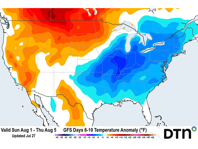
The first is that the trough in the east will become much more pronounced next week. The western ridge has taken over a lot of the U.S. this week with temperatures in the 100s Fahrenheit in the Plains and 90s across the rest of the country. Next week, the trough in eastern Canada will deepen southward across the eastern U.S. Cooler air from Canada will filter southward into the country, putting an end to much of the heat east of the Rockies. But that will not be true for everyone.
Meanwhile, the ridge in the West strengthening this week will pulse back to a weaker one next week, allowing a storm system to potentially push through it toward the end of next week. While temperatures will remain high in the West, Northern Plains, and Canadian Prairies, we may see a sneaky storm system move through that produces good rainfall for these areas. A caveat is that models are waffling on this potential storm. That should not be surprising this far out, but it gives hope for corn and soybean producers for a better chance at some timely rainfall as time is running out for this season.
With only limited precipitation across the Corn Belt during the last week, crop conditions fell across many states. This was most notable in the Western Corn Belt states of North Dakota, Minnesota, Iowa, and Kansas. Eastern Corn Belt states saw more of an increase as saturated soils drained, the sun came out, and temperatures rose.
Still, even with the more favorable crop conditions in the Eastern Corn Belt, the abysmal conditions in portions of the Western Corn Belt, particularly in the Dakotas and Minnesota, has crop conditions near or below average for this time of year. And spring wheat has even worse good-to-excellent ratings than 1988, leading many to wonder how much spring wheat will be harvested this year, and how much will just be abandoned.
But there is still some time for corn and soybeans. While the outlook does not look good on the whole, the limited rainfall chances for the Western Corn Belt should provide timely rains for some areas. The differences between the "haves" and "have-nots" will continue through the rest of the season.
John Baranick can be reached at john.baranick@dtn.com
(c) Copyright 2021 DTN, LLC. All rights reserved.