
Best Blog of the Week
Ag Weather Forum: Plains Drought Relief Continues
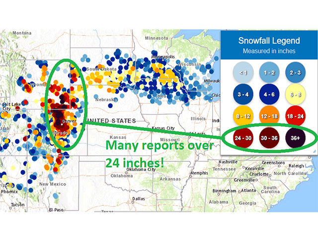
The weekend storm that developed March 13-15 was quite the doozy, even by spring standards. Widespread 1 to 3 inches of precipitation fell in a box bounded by Texas Panhandle to eastern Arkansas up through South Dakota and over to Minnesota. Heavier amounts of roughly 3 to 5 inches fell in Nebraska and along the front range of the Rocky Mountains from Colorado up through Wyoming and far western Nebraska and South Dakota. This latter area culminated in snow as opposed to rain and the amounts were incredible. Snowfall reports of over 24 inches were recorded and amounts over 40 were dotted in a couple of spots in Colorado and southeast Wyoming near Cheyenne.
When the new Drought Monitor is released on March 18, we should expect to see both a reduction in drought coverage area and category of severity across the Plains and Midwest. The drought severity may be reduced by one or perhaps two categories.
One storm is not enough to eliminate a long-standing drought that has lasted nearly a year, but the reductions will be significant. With some of this coming in the form of snow, a slower release into the soil profile will help to fill subsoils more efficiently as opposed to the straight rain that has fallen elsewhere. It is the subsoils that need to fill up before the long-duration droughts disappear.
But the topsoil moisture reaching saturation is beneficial in the area for winter wheat that is coming out of dormancy. Soil moisture estimates of greater than 40% above-normal soil moisture are found across a wide area of Kansas, Oklahoma, the Texas Panhandle, and southeast Colorado, helping plants green up.
P[L1] D[0x0] M[300x250] OOP[F] ADUNIT[] T[]
True, temperatures here are below normal and will be for the majority of this week and possibly into the next, but the soil moisture is beneficial, nonetheless.
The previous storm is not the only storm to bring widespread moderate to heavy precipitation to the region. As of March 16, another storm is moving through the Four Corners region. This storm will move into the Texas Panhandle this evening and spread more widespread showers through the Central and Southern Plains and continue through the Midwest, Delta, and Southeast through the end of the current week.
Forecast rainfall amounts may eclipse 1 inch again across a wide area from the Texas Panhandle through Kansas and the southern Midwest and in portions of the Delta and Southeast as well. Outside of flood risks, this storm will add to the beneficial rainfall across these areas, helping to green winter wheat and prepare soils for spring planting.
Spring rainfall is upon us and so is the risks of severe weather. As this system works through the Delta and Southeast, the combination of a deepening storm with juicy Gulf of Mexico moisture will produce strong thunderstorms. The Storm Prediction Center indicates the greatest risks from the Delta to Alabama March 17, including a moderate risk for tornadoes.
The SPC does not joke around when it starts to issue moderate risks of severe weather. This typically corresponds to expected outbreaks of tornadoes or widespread severe windstorms. In this case, we may see both on March 17 followed by a continuing line of severe storms across the rest of the Southeast on March 18.
In contrast to the widespread precipitation, the far northern Plains through the Canadian Prairies has seen dryness from the winter continue into the spring. South Dakota was lucky to see some moderate to heavy snow from the previous system, but Montana and North Dakota saw very little. The area will miss out on the next storm as it passes to the south, but a front moving through this weekend into early next week across the Plains may bring at least some showers through the region.
This system will likely develop into two pieces next week as a portion of the storm gets cut off from the main flow in the Four Corners region, while the other piece advances along the U.S.-Canada border region. Both pieces will have the potential to bring about more widespread showers through the Plains and Midwest, with the second piece more likely to miss the Northern Plains. What appeared to be a below-normal month for precipitation across the majority of the country early this month now looks like it will be near to above normal.
Producers are likely breathing a quick sigh of relief to see these storms lining up. But we must remember that we remain in a neutral to weak La Nina pattern through this growing season. La Nina tends to produce warmer weather and drier conditions, particularly in the summertime. Even though we may see some better conditions early this spring, we cannot lose sight of the fact that crop conditions are likely to see more unfavorable weather as the season progresses.
John Baranick can be reached at john.baranick@dtn.com
(c) Copyright 2021 DTN, LLC. All rights reserved.