

Delta Braces for Heavy Rain and Wind
Tropical Storm Laura to Lash Delta
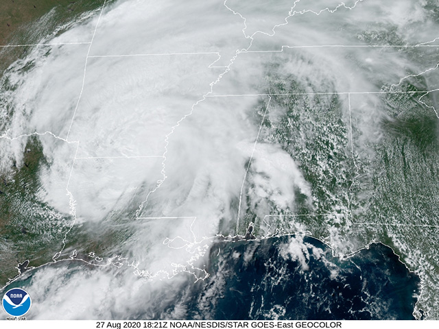
OMAHA (DTN) -- Former Category 4 Hurricane Laura, downgraded to tropical storm status Thursday, continued its trek north through northern Louisiana and southern Arkansas as a damaging rain and wind producer. Thursday afternoon analysis showed Laura sustained winds of 65 miles per hour and moving northward at 15 mph. The storm center was in northern Louisiana 65 miles east-northeast of Shreveport, Louisiana.
Laura is forecast to weaken to a tropical depression during Thursday evening or overnight into Friday. Prior to the downgrade to tropical depression status, heavy rain and wind potential are on the minds of producers from the storm's track east into the Mississippi Delta.
Delta producer Jeremy Jack near Belzoni, Mississippi, was most concerned about high-wind damage to cotton in advance of the arrival of Hurricane Laura. Most of the Delta east of the Mississippi River was in an area with "limited" wind risk in National Weather Service bulletins Thursday; western portions of the region had an "elevated" wind damage threat.
P[L1] D[0x0] M[300x250] OOP[F] ADUNIT[] T[]
"Cotton is still not ready to defoliate ... a worst-case scenario for whoever is in the way of a hurricane," Jack said.
As far as cotton impact is concerned, evidence of damage is undetermined at this point. "We would say any serious assessment of damage to Texas/Louisiana has yet to be initiated (following Laura's landfall)," wrote DTN Contributing Cotton Analyst Keith Brown Thursday.
Rice futures were sharply higher, though, and related to the impact of Tropical Storm Laura. Its track put rice acreage in Louisiana and Arkansas in the path of heavy rain and high winds.
As Laura goes through its foray through the interior United States, the track is forecast to veer eastward close to the Ohio River and eventually to exit the contiguous U.S. off the Mid-Atlantic coast Saturday evening, Aug. 29. Laura is expected to leave a narrow swath of heavy rain from northern Arkansas through the Missouri Bootheel, then traverse Kentucky and northern Tennessee, West Virginia and Maryland. The storm's short duration in the interior U.S. is forecast to limit its rain potential for the majority of the Midwest.
Bryce Anderson can be reached at bryce.anderson@dtn.com
Follow him on Twitter @BAndersonDTN
(c) Copyright 2020 DTN, LLC. All rights reserved.