

Crop Risk From Hurricane Laura
Rain and Wind Threaten Cotton Ahead of Harvest
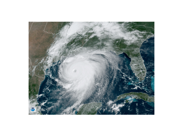
OMAHA (DTN) -- Hurricane Laura in the Gulf of Mexico continued to track toward the Texas-Louisiana coast Wednesday afternoon. The storm reached "catastrophic" Category 4 status early Wednesday afternoon, according to the National Hurricane Center (NHC). The NHC also described the hurricane as "a formidable hurricane" in recent hours, threatening to smash homes and sink entire communities. An early Wednesday bulletin from the NHC noted that Laura had undergone a remarkable intensification, "and there are no signs it will stop soon," the Hurricane Center said.
Damage to homes, communities, oil rigs, transportation and human safety threats are widely circulated. The storm, however, also threatens to damage crops in the Gulf Coast and portions of the Delta on its track inland after making landfall early Thursday near Lake Charles, Louisiana.
The hurricane's track is most threatening to crops in the Delta (Mississippi, Louisiana, Arkansas, the Missouri Bootheel and Western Tennessee). DTN contributing cotton market analyst Keith Brown said that "of those states, Louisiana is 40% bolls open and Arkansas is about 23% open. The others' fields are just emerging." Those open-boll fields of Louisiana and Mississippi could incur extensive damage in Brown's opinion. "Heavy rains and fierce winds could zap some of the lower extremities of the Delta with more than a 50% loss."
P[L1] D[0x0] M[300x250] OOP[F] ADUNIT[] T[]
Cotton has also sustained hurricane damage on the South Texas coast earlier this season. "Most coastal cotton is down around the Brownsville/ Corpus Christi area. Unfortunately, this cotton was pummeled by Hurricane Hannah early in the season," Brown said.
Farther north, rainfall from the remnants of Hurricane Laura after it makes landfall may benefit a portion of the Midwest, especially the southern portion of the region.
"On Friday, the system moves east across the northern Delta," said DTN Ag Meteorologist John Baranick. "The rain shield may extend a few counties north of the Ohio River Friday and Saturday."
A more prominent effect from Laura in the Midwest may be its addition to rainfall prospects in the eastern Midwest during the end of August and the beginning of September.
"Overall, the storm's impact looks to be more of a moisture pump for a frontal boundary that will work its way south through the Midwest. The combination of Laura and the front will bring moderate to heavy rainfall east of the Mississippi River," Baranick said.
Bryce Anderson can be reached at bryce.anderson@dtn.com
Follow him on Twitter @BAndersonDTN
(c) Copyright 2020 DTN, LLC. All rights reserved.