

Best Blog of the Week
Ag Weather Forum
Summer 2020 is well on its way to being remembered as a hot summer over much of the central United States. That goes along with how the year 2020 is developing worldwide. The NOAA National Centers of Environmental Information places June 2020 tied as the third-warmest June on record for the globe, with the first half of the year at a near-record-warm level.
This warm pattern is occurring with both daytime and nighttime temperatures supporting heat stress. During a climate review webinar covering the central region of the contiguous U.S., Nebraska State Climatologist Martha Shulski said that June featured record-warm overnight minimums in Nebraska, Iowa and South Dakota. "The warm nights do not allow plants to respirate," Shulski said.
Excessive heat during the upcoming July 17-19 along with the chance for the final week of July are primary weather concerns. "Heat indices of 100 to 115 are possible," said NOAA Central Region Director Doug Kluck. "And the warm nights mean there will be no cooling and thus more stress for humans, livestock and crops."
The level of impact is being watched. "The upcoming excessive heat ... is coming at a time that is undesirable for corn production," said Shulski, referring to crop stress from both daytime and nighttime heat.
P[L1] D[0x0] M[300x250] OOP[F] ADUNIT[] T[]
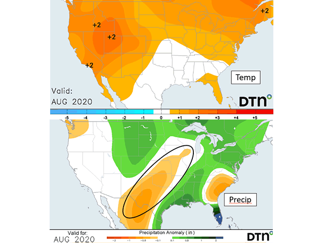
Looking to August, temperatures running above normal and precipitation showing much variability are featured in both public and private forecasts. In DTN's forecast view, the Northern Plains, eastern Midwest, and the southeastern U.S. have a high probability of above-normal precipitation. But a broad swath of the western and southwestern Midwest through the southern Plains has below-normal precipitation indicated. This is occurring even with the Pacific Ocean temperature pattern still not in a cool La Nina pattern yet.
A long-wave atmospheric feature in the Indian Ocean known as the Madden-Julian Oscillation (MJO) may be lining up to help enforce the hotter pattern with the wide temperature variability. This feature, known as a teleconnection, helps describe the broad-scale atmospheric activity in long waves across the globe.
"Indian Ocean Convection is a teleconnection that would promote ridging further downstream. This isn't always the case at each time of year," said DTN long-range forecaster Nathan Hamblin. "Wavelengths change and this changes what the MJO actually does to the pattern over the U.S. Sometimes this can change within a month."
Hamblin noted that the MJO may be in a phase of its cycle that would be well-timed to bring central U.S. heat and dryness during August. "Let's take MJO phase 3 in August as an example," he said. If you have that going during the first 10 days of August at an amplitude of 2 sigma or higher (meaning much above the average in measurement), then a ridge would be forecast across the Midwest, which would promote heat and likely dry weather. (Ridge refers to upper-level high pressure, which in summer translates to hot and dry conditions.)"
Timing of this oscillation getting going will be important, said Hamblin. "However, if that same convection occurs during the last 10 days of August, ridging would be more likely across the Southwest ... most major features are still there, but they seem to be retrograded a little. This is due to the beginning of the change of season toward somewhat shorter wavelengths."
Another feature that offers a point of concern for the late summer pattern turning drier and staying warm to hot is how analog years line up. Years identified by DTN forecaster Jeff Johnson with conditions as are in effect in 2020, including the trend of the Pacific Ocean to a weak La Nina, show an above-normal temperature trend in much of the Midwest along with a large portion of the Midwest with below-normal precipitation.
This supports some concern about the prospect for hotter and drier August weather in the interior U.S. Nervousness and uncertainty lie ahead as we approach the last third of the summer season.
Bryce Anderson can be reached at bryce.anderson@dtn.com
Follow him on Twitter @BAndersonDTN
(c) Copyright 2020 DTN, LLC. All rights reserved.