
DTN Ag Weather Brief
DTN Ag Weather Brief
The northern branch of the jet stream features a weak ridge over Alaska. The polar vortex over northern Canada and a weak ridge over Greenland. This is producing mild temperatures over western Canada, cool in the east. The southern branch of the jet features a trough in the eastern pacific/Gulf of Alaska. A migratory trough over the southwest U.S. Some ridging over the northwest U.S. and a trough along and off the east coast of the U.S. Subtropical high pressure is centered over southern Mexico and Hispaniola.
EXTENDED OUTLOOKThe operational run of the U.S. and European models are in fair-poor agreement days 7-10. We are leaning towards the European model. During the 6-10 day period the northern branch of the jet stream will feature a blocking ridge to the north of Alaska. A trough over northern Canada and some weak ridging over Greenland. This will produce variable temperatures across southern Canada, The southern branch of the jet will feature a trough in the eastern pacific/Gulf of Alaska. A ridge over the western U.S. A trough over the central and eastern U.S. and a ridge in the western atlantic. It appears that the speed of movement of systems within the trough will limit precipitation in much of the central U.S. Only the southeast Midwest and Delta states could pick up some significant precipitation along the boundary zone between the trough and the ridge. This would be later in the period as more southern branch trough develops over the south-central U.S. Temperatures will start out the period very cold as arctic air moves southward out of Canada with the northern branch trough. However, some moderation is expected later in the period as this trough lifts off to the northeast and more moderate pacific air moves in.
This pattern will feature near to above normal temperatures in the Midwest during the next 5 days, variable days 6-10. Precipitation below normal during the next 5 days, near to below normal days 6-10. The northern plains will see variable temperatures. Precipitation near to below normal during the next 5 days, below normal days 6-10. The southern plains will see near to above normal temperatures during the next 5 days, variable days 6-10. Precipitation below normal during the next 7 days, near to below normal days 8-10. The Delta states will see near to above normal temperatures during the next 5 days, variable days 6-10. Precipitation below normal during the next 5 days, near to above normal days 6-10.
Mike Palmerino
DTN Senior Ag Meteorologist
NATIONAL TEMPERATURE/RAINFALL EXTREMES:HIGH WED...87 AT FALCON LAKE TX
LOW WED...10 BELOW ZERO AT COPPER BASIN ID
24 HOUR RAINFALL ENDING AT 7 PM YESTERDAY…BUFFALO NY 1.23 INCHES
US OUTLOOK AND MODEL DISCUSSION 6-10 DAY PERIOD:The US and European models are in fair to good agreement only for the first day or two of the outlook period, after that fair to sometimes poor agreement.
A difficult call today. I favor a little more of the European model for much of the period but I am a little uncertain for the end of the period.
Today's US model features much colder weather lasting much further into the outlook period for both the plains and Midwest regions. The storm track is pushed well to the south and east during this period with most areas outside of the central and southern east coast states and the gulf coast states drier.
The European model is fairly cold but for a shorter period early in the period, especially over the central and southern plains winter wheat belt.
Later in the period the model shows a deepening upper level trough over the Midwest region and a storm system moving northward over the eastern US. This suggests heavier precipitation through the east coast states on the warm side of the Midwest trough and light to moderate precipitation in the Delta, the southeast and east areas of the Midwest region.
The key features on today's mean maps covering the 8-10 day period will be the high latitude blocking ridge either north of Alaska using the European model or east of Alaska using the US model. The polar trough is centered north of Hudson bay on the European Model and over southeast Canada and the Great Lakes region using the US model. This further southeast position of the trough on the US model is the reason this model is much colder further to the south than the European model. The European model also features a stronger west coast ridge, a somewhat stronger trough over the Miss river valley and a further west position for the west Atlantic ridge. This suggests more and heavier rain between the Miss river trough and the west Atlantic ridge or basically most of the east coast states. The stronger west Atlantic ridge is likely the reason for the deepening trough mentioned above and the heaviest precipitation chances in the eastern US.
MAJOR WORLD HIGHLIGHTS/IMPACT:
NORTHERN PLAINS (CORN,SOYBEANS,LIVESTOCK): A mainly dry period lasting 7 to 10 days along with warmer temperatures lasting a few more days will help melt snow cover. However, low sun angle and length of day will considerable slow this process this time of the year. Improving conditions for livestock, until the next Arctic outbreak moves in later in the weekend and for much of next week.
Little additional harvesting of corn or soybeans is expected this week.
CENTRAL/SOUTHERN PLAINS: Some beneficial rainfall for winter wheat during the past week. Although in southwest Kansas and southeast Colorado it remains too dry. No significant rain is expected during the next 10 days. No significant cold weather impacts are expected this week. However, next week we will need to watch the movement of the Arctic outbreak expected to hit the northern plains area late this weekend and early next week.
MIDWEST (CORN, SOYBEANS, WHEAT): Wet conditions due to recent rain, some heavy rain, delays the remaining harvest. Some corn may be left in the fields until spring. Any soybeans remaining in the fields may be lost. Some improvement is possible during the next 7 days or so as it looks drier, especially west and north areas.
BRAZIL (Soybeans/full season corn): Favorable conditions for developing soybeans throughout the major growing areas with beneficial rains last week and more shower activity during this week as well. Above normal temperatures and below normal rainfall continues to impact soybean planting and development in the minor northeast areas (Bahia).
ARGENTINA (CORN/SOYBEAN): Mostly favorable conditions for planting and early development of corn and soybeans in the major growing areas. However, a drying trend during the next 7 days will need to be watched as some locations have not received much rainfall recently. Dryness is especially evident over northern Buenos Aires due to less than 50 percent of normal rainfall during the month of November.
SOUTH AFRICA (MAIZE/SUGARCANE): Improving conditions for planting and development of maize and sugarcane areas due to increasing rain activity and cooler temperatures during this week. Some delay to planting due to the wet weather, at times.
P[L1] D[0x0] M[300x250] OOP[F] ADUNIT[] T[]
AUSTRALIA (SORGHUM/COTTON/SUGARCANE): Showers have been in key growing areas for sorghum and cotton during the past week while the sugarcane areas remained drier. The rainfall may favor development of the sorghum and cotton crops but it is not enough to ease drought conditions or to improve irrigation supplies.
Rainfall during the next 10 days likely averages below normal.
EXPANDED SUMMARIES FORECASTS:
Midwest (corn, soybean and winter wheat)
Summary:
West: Mostly dry. Temperatures above normal.
East: Mostly dry. Temperatures above normal.
Forecast:
West: Mostly dry today through Saturday. Temperatures average above normal today, below normal Friday, above normal again Saturday.
Mostly dry during the daytime hours of Sunday. Light precipitation, up to 0.25 inch melted, favoring northern areas Sunday night through early Monday.
Mainly dry Tuesday. Temperatures average above normal Sunday, below normal north and west and above normal southeast Monday, below to well below normal Tuesday.
East: Mostly dry today. Dry or with only a little light precipitation through the lower Ohio River valley during Friday. Mainly dry Saturday. Temperatures average above normal west and near normal east today, near to below normal north and near to above normal south tomorrow, near to above normal west and below normal east Saturday.
Mostly dry Sunday, a little light precipitation Sunday night. Light to locally moderate rain southern and east-central areas and light mixed precipitation northern areas during Monday. Drier during Tuesday. Temperatures average above to well above normal Sunday and Monday, below normal west and above normal east Tuesday, below to well below normal Wednesday.
6 to 10 day outlook: Temperatures average below to well below normal west, near to below normal east, during this period. Precipitation near to below normal.
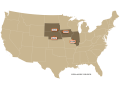
Northern Plains (Corn, Soybeans, Spring Wheat)
Summary: Mostly dry. Temperatures above normal.
Forecast: Mostly dry today and Friday. Dry or with only a little light precipitation in the west during Saturday. Temperatures average above normal today, near to above normal Friday, above normal Saturday.
Light precipitation, favoring western and southern areas, during Sunday.
Drier Monday. Dry Tuesday. Temperatures average below normal Sunday, below to well below normal Monday and Tuesday.
6 to 10 day outlook: Temperatures average well below normal Tuesday and Wednesday, above normal west and well below normal east Thursday, above normal west and near normal east Friday and Saturday. Precipitation below normal.
Central and Southern Plains (Winter Wheat/livestock)
Summary: Mostly dry. Temperatures above to much above normal.
Forecast: Dry or with only a little light precipitation favoring western and southeast areas today or during tonight. Mostly dry tomorrow and Saturday.
Temperatures average above to well above normal today, near to above normal tomorrow, above normal north and west and near normal southeast Saturday.
Mostly dry or with only a little light precipitation Sunday and Monday. Dry Tuesday. Temperatures average above normal Sunday, near to below normal north and above normal south Monday, below normal Tuesday.
6 to 10 day outlook: Temperatures are expected to average below normal early in this period, near to above normal late in the period. Precipitation near to below normal.
Brazil Soybeans…
Rio Grande do Sul and Parana…
Summary: Light to moderate showers through RGDS during the past 24 hours.
Heavier showers and thundershowers in Parana during this time. Temperatures averaged near normal south, below normal north.
Forecast: Light to moderate showers and thundershowers mainly in Parana during today. Mostly dry tomorrow and Saturday. Temperatures average below normal during this period.
Mostly dry Sunday and Monday. Dry or with only a few light showers during Tuesday. Temperatures average near to above normal south, near to below normal north, during this period.
Mato Grosso, MGDS and southern Goias...
Summary: Light to moderate showers with locally heavier during the past 24 hours, heaviest southern and eastern areas. Temperatures near to below normal south and east, near to above normal northwest.
Forecast: Scattered light to moderate showers and thundershowers today. Showers north and east, drier southwest, tomorrow and Saturday. Temperatures average near to below normal south and near to above normal north during this period.
Scattered showers favoring Mato Grosso and Goias Sunday and Monday.
Scattered thundershowers may redevelop in MGDS during Tuesday. Temperatures average near to below normal south, mostly near normal north.
Argentina Corn and Soybeans…
Cordoba, Santa Fe, north Buenos Aires...
Summary: Mostly dry through south and central areas. Light showers north with a few moderate showers northwest during this time. Temperatures below normal.
Forecast: Mostly dry today and Friday. Dry or with only a few light or very light showers during Saturday. Temperatures average below normal today, near to above normal tomorrow and Saturday... warmest western areas.
Mostly dry or with only a few light showers Sunday through Tuesday.
Temperatures average above normal, possibly well above normal.
Joel Burgio can be reached at joel.burgio@dtn.com
DTN Senior Ag Meteorologist
(BAS)
Copyright 2019 DTN/The Progressive Farmer. All rights reserved.