

Canadian Prairies Weather Outlook
Active Pattern Not All That Helpful in Canadian Prairies
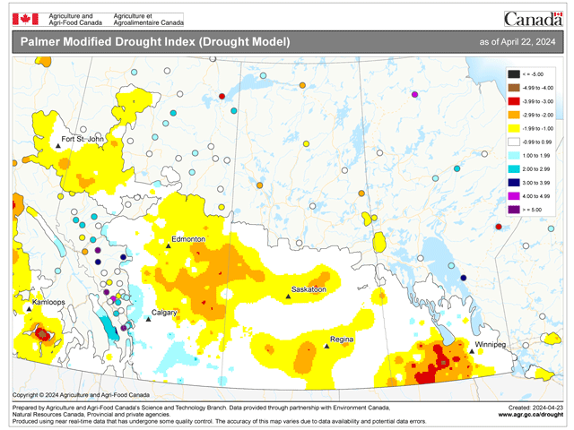
Drought still remains across the Canadian Prairies. Though we do not have an update from the North American Drought Monitor since the end of March, it is unlikely that the situation has resolved itself in a widespread way. That is despite a more active weather pattern across the region in April that has brought significant precipitation to northern Saskatchewan and most of Manitoba.
Data from Agriculture and Agri-Food Canada displays that these areas have received more than 25 millimeters (1 inch) during the last two weeks.
Some relief to the drought will occur because of this, but elimination of longer-term deficits are not going away. It was much drier over Alberta and southern Saskatchewan during the same period, with less than 10 mm (0.4 inches) recorded in most areas outside of a small strip south of Calgary that recorded between 10 and 20 mm (0.4-0.8 inches).
P[L1] D[0x0] M[300x250] OOP[F] ADUNIT[] T[]
Precipitation was much better in southern Alberta earlier in April that may have eased drought. Central Alberta into west-central Saskatchewan is where drought currently is noted as being the worst, and rainfall in April has continued to be below normal.
With that in mind, an active weather pattern would be preferred to build in some soil moisture as planting starts to increase during the next few weeks, especially across the west.
The pattern will indeed be active, but it may not be enough. Storm systems will continually move through the region and farther south for the next two weeks, but the scope of precipitation coverage and intensity of the precipitation will not bring much relief to the region. Both the European and American models have less than 30 mm of precipitation in the 10 days through May 5 across most of the territory.
There are some major disagreements between the models, which should be expected when we see at least five different storm systems moving through the region during that course of time. But the differences do not add up to much more than those 30 mm. The European model hits northeastern Alberta with more than 50 mm while the American GFS puts similar amounts against the Canadian Rockies and Peace region. But they agree on the 30-40 mm over southeastern Saskatchewan and southern Manitoba that should help out the drought there after the most recent rainfall.
Despite the active pattern, and the overall lower intensity, the potential for near-daily rain chances for the next 10 days will likely limit fieldwork across the region. That is especially true if the precipitation comes down as snow rather than rain. These systems are not tapping into a lot of cold air, but perhaps cold enough to turn some areas of rain into snow at times. The chances for snow are highly suspect at this time of year, though. And without a significant large-scale storm system to drive it, forecasts for snowfall will likely be variable in both space and time. If you do see snowfall in your forecast, I would suspect to see changes with that over time.
To find more international weather conditions and your local forecast from DTN, head over to https://www.dtnpf.com/…
John Baranick can be reached at john.baranick@dtn.com
(c) Copyright 2024 DTN, LLC. All rights reserved.