

Ag Weather Forum
Widespread Severe Storms for Middle America Friday
We are in the thick of severe weather season and after last week's severe weather across the south with a strong storm system, we have yet another risk of severe storms for today.
A deep low-pressure center currently located in northwest Iowa carries a cold front through the Central Plains back into western Texas early Friday morning. Other thunderstorms have developed across the Midwest and Tennessee Valleys as upper-level energy has overspread the area and moist flow has returned off the Gulf of Mexico.
P[L1] D[0x0] M[300x250] OOP[F] ADUNIT[] T[]
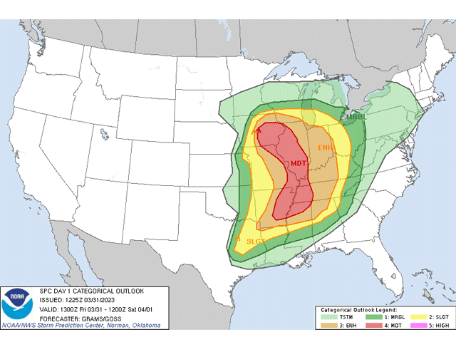
All of the ingredients are there for a widespread severe weather event for the day. Storms are likely to occur in two different areas. The first will be in lines, clusters, or induvial storms ahead of the cold front across Missouri and Arkansas by midday. Rich moisture and an increasing wind field will lead to widespread coverage of storms by the afternoon. The second will be along the cold front from Iowa into northern Missouri in the early afternoon. These storms will race east across Illinois and into Indiana by the evening.
Both areas carry risks for widespread strong to severe storms with all modes of severe weather being possible, including large hail, strong winds and tornadoes. Both areas should turn into lines of storms by the evening, evolving more into a damaging wind threat with time. The Storm Prediction Center is concerned yet again for another strong, long-track tornado outbreak, indicated with their large Moderate Risk in the Mississippi Valley.
The main difference from this week to last week is the widespread nature of the threat, covering a much wider area of the country, the first of the year for large areas of the Midwest. Another strong severe event is expected in a similar area on April 4. This should be no surprise, given the active pattern during the start of severe weather season.
To find updated radar and analysis from DTN, head over to https://www.dtnpf.com/…
John Baranick can be reached at john.baranick@dtn.com
(c) Copyright 2023 DTN, LLC. All rights reserved.