

Recapping the Drought of 2021
Year-Over-Year Wheat Production Numbers Tell Story of 2021 Drought Across US
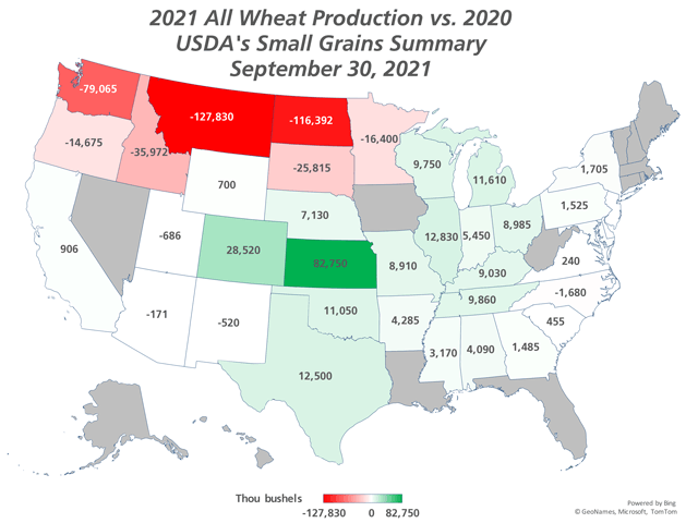
"A picture is worth a thousand words." I do not know where to attribute that quote, but the accompanying image is certainly able to illustrate in fairly good detail the weather patterns over the spring and summer of 2021.
Drought moved in and out of the Plains and Pacific Northwest, all good wheat country. Production numbers from these states, and those in the Midwest, tell the story of the weather patterns through the major production areas -- the "haves and have-nots" -- rather well.
If you were to look at the drought picture on March 2, 2021, you would see moderate to severe drought across the Northern and Central Plains as well as much of Texas. Patchy drought conditions would also be found in the Upper Midwest and Pacific Northwest with extreme and exceptional drought across the Southwest. Meanwhile, soft red winter wheat areas from the Delta into the Midwest were nearly drought-free. Certainly, there were large concerns to start the season for hard red winter wheat in the Central and Southern Plains, white wheat in the Pacific Northwest, and spring wheat in the Northern Plains. Conditions worsened over the winter in the Northern Plains but actually improved some in the Central and Southern Plains, especially in Texas.
But La Nina was still in control at that point in the year, and typically, it leads to hot and dry conditions over the winter and early spring in the Central and Southern Plains. While spring was just starting up, there was concern that La Nina would reverse course for the region's wheat areas before giving up its grip and turning neutral later in the spring. Instead, the month of March was good to the Central Plains as Nebraska and Kansas saw their drought nearly eliminated by April 6, a process that would be completed in the middle of May and extend its way south through almost all of Oklahoma and Texas as well.
The reverse occurred in the Northern Plains and Pacific Northwest during the spring months. System after system found a clear path through the Central and Southern Plains and would move generally eastward, leaving the Dakotas and Montana extremely dry. The systems did start out moving through the Pacific Northwest, but each of these were unable to tap into any significant moisture until exiting the Rockies, where access to the Gulf of Mexico moisture source was easy and plentiful. That brought good moisture through the Central and Southern Plains, Delta, and eastern Midwest regions, which continued to have plentiful moisture through reproductive portions of the winter wheat's growing season.
P[L1] D[0x0] M[300x250] OOP[F] ADUNIT[] T[]
The weather pattern abruptly changed in early June. A strong ridge of high pressure developed across the western U.S. and remained parked there through mid-August. Extreme heat with record temperatures in several states occurred. Temperatures regularly hit triple digits for those 80 or so days, and the regions suffered near-complete dryness. Drought coverage and intensity grew through the summer across the West and the Plains. But the effect on winter wheat was not significant. Already filling when the heat struck, soil moisture was adequate from Nebraska southward to finish out the crop. That was not the case for white wheat in the Pacific Northwest, where drought had grown through the spring. And it was completely devastating in the Northern Plains.
Rain did not shut down in the Plains completely, but instead of coming via occasional organized thunderstorm clusters, it was only isolated cells that moved through on rare occasions. Many areas fell 8 to 10 inches behind normal for the year, and some found even worse conditions up in the north. By the time rains returned to the Western Corn Belt in mid-August, the damage was beyond repair, and over half of the spring wheat crop had already been harvested. DTN has written about this previously, which you can read here:
-- " Wheat Bull Hiding in Plain Sight," https://www.dtnpf.com/…
-- " USDA Reports Review," https://www.dtnpf.com/…
-- "Ag Weather Forum: Continued Drought for North-Central US," https://www.dtnpf.com/….
-- "Spring Wheat Tour: Final," https://www.dtnpf.com/….
But when you look at USDA's Grain Stocks report that was released on Sept. 30, you can clearly see the effect drought had on the country's agricultural production from March through September.
In the map accompanying this article, the incredible drought that has persisted and worsened for months in North Dakota and Montana sticks out like a sore thumb with production falling by enormous amounts. The adjacent states of South Dakota and Minnesota along with the Pacific Northwest saw huge reductions as well. But the great spring weather allowed much of the hard red winter wheat in the Central and Southern Plains see much better yields from Nebraska south to Texas. Soft red winter wheat saw good production, as well, from Arkansas up through Michigan and Ohio.
In my opinion, the year-over-year production of wheat perfectly tells the story of drought across the U.S. over the last six-to-seven months. The forecast is not pointing to any significant reduction in the drought through winter of 2021-2022 and worsening drought across the Central and Southern Plains. Will wheat production capture the story of the drought in 2022 so perfectly as well? I will let you know in a year.
John Baranick can be reached at john.baranick@dtn.com
(c) Copyright 2021 DTN, LLC. All rights reserved.