

Ag Weather Forum
Rain-Delayed Western Corn Belt Harvest Shows Strong Resemblance to 2018
Harvest season 2026 has been a slow slog for many producers in the Western Corn Belt.
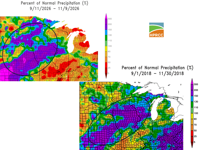
The time period from Sept. 11-Nov. 9, 2026 saw precipitation of 10 to 15 inches for much of the western and northern Corn Belt. This includes almost all of the state of Iowa except for the northwestern portion. "Iowa is running around the 6th warmest and 5th wettest through Nov. 9, 2026," noted state of Iowa climatologist Justin Glisan in an email.
P[L1] D[0x0] M[300x250] OOP[F] ADUNIT[] T[]
Wet fields and wet crops have definitely slowed down harvest. Iowa's corn harvest through Sunday, Nov. 8, was just 72% complete, 17 percentage points behind average. Nebraska, with corn harvest progress of 74% (10 percentage points behind average), was also slowed down by heavy rain as the 2026 crop season came to a close. Much of this delay was set up during September's heavy precipitation. For example, State of Iowa records show that in September 2026, Iowa's average precipitation totaled 7.83 inches or 4.35 inches above normal. That was the fourth-wettest September in 154 years of records for Iowa.
The end of this growing season was wet -- but it was not without recent precedent. Conditions in the fall season of 2018 also featured heavy precipitation, which caused a notable slowdown in corn harvest. In 2018, Iowa precipitation totaled 7.89 inches, or 4.51 inches above normal. That's slightly more than 2026's numbers and was the third-wettest September among the observational record.
The two crop years, 2026 and 2018, show some differences in precipitation totals in Iowa. Crop year 2018 featured precipitation that totaled 4.49 inches, or 1.88 inches above normal in October, the seventh-wettest October on record. In 2026, Iowa's October precipitation totaled 2.88 inches, or 0.19 inch above normal and the 59th-wettest on record.
In November, wet conditions have returned. For the week ending Sunday, Nov. 8, Iowa had more rain than a typical monthly total for November. The state's weekly average precipitation was 1.47 inches, more than triple the normal amount of 0.48 inch. That is a departure from 2018; back then, drier conditions had formed in much of the state during November. Moving into the midpoint of November, a drier pattern is allowing for improved field conditions and harvest progress. However, harvest is still likely to be slowed down by slow-drying fields and roads. The last leg of harvest could take a while at least to finally be brought in thanks to the fall rains of 2026.
Bryce Anderson can be reached at bryce.anderson@dtn.com
(c) Copyright 2026 DTN, LLC. All rights reserved.