

Midwest Derecho Anniversary
One Year Later: A Look at 2020's Destructive Derecho
A year ago today, an incredibly strong weather event dubbed a "derecho" occurred over the Midwest. The strong windstorm moved through much of the most lucrative cropland in the Heartland of America and caused widespread destruction.
You can see DTN's extensive coverage of the 2020 Midwest derecho and its impact at this site: https://spotlights.dtnpf.com/….
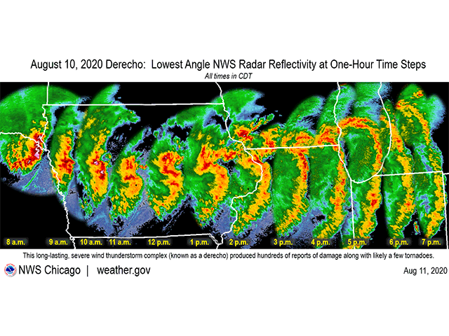
The derecho was almost completely unexpected. Thunderstorms that developed over southeast South Dakota and northeast Nebraska in the early morning of Aug. 10, 2020 seemed like many thunderstorm clusters that occur during the overnight hours. They look good on radar, but due to stable air near the ground, rarely translate to severe weather at the surface.
The Convective Outlook issued by the Storm Prediction Center (SPC) just a few hours earlier hardly even mentioned a risk for severe weather that day across Iowa and Illinois, instead focusing on later-day thunderstorms developing along a front from Kansas into central Illinois.
But as storms developed overnight, the SPC issued a mesoscale discussion just after 3 a.m. to discuss the potential for stronger storms that the center was monitoring across southern South Dakota and northern Nebraska. The SPC was giving the region a probability of 40% chance for issuing a Severe Thunderstorm Watch. About three hours later, one of these clusters looked the part of strong and severe so the SPC issued a Severe Thunderstorm Watch.
As the cluster moved into Iowa, it stopped being elevated and became connected to the surface layer and the derecho was born. It started as a bowing segment in far eastern Nebraska and western Iowa but grew into a significant windstorm. Nearing the Interstate 35 corridor, instability increased and allowed winds to strengthen substantially and develop a rear-inflow jet. This is a zone of strong winds at the rear of the storm that aids in creating a stronger cold pool, downdraft, and forward speed. It is a characteristic of significantly strong thunderstorm complexes and this one certainly was.
P[L1] D[0x0] M[300x250] OOP[F] ADUNIT[] T[]
As the system raced across eastern Iowa, wind speeds reached 80 to 120 miles per hour, the same as a Category 1 or 2 hurricane. The small zones that saw wind speeds reach more than 110 mph found Category 3, or major hurricane wind speeds.
As the system moved into northwest Illinois, it started to weaken with winds more in the 70-100 mph range until getting into northeast Illinois and weakening further as it moved through Indiana. Though the system was weaker, it was not done producing damage. It produced 15 tornadoes in Illinois and three in Indiana, mostly rated EF0 or EF1.
We all know wind speeds of this magnitude cause devastating damage to coastal areas. We see it on the news every time a hurricane moves through. But going over land caused more damage than Category 2 Hurricane Sally, Category 4 storm Delta, and Category 3 Hurricane Zeta.
The total monetary damage was estimated at $11 billion, making it the most costly thunderstorm in U.S. history.
The power was out in Cedar Rapids, the hardest hit area, for almost two weeks before everyone got back online. Agriculturally, debris was thrown across fields and made it difficult and costly to harvest. Iowa and Illinois were hit the hardest and it was estimated that more than 10 million acres of Iowa's corn and soybean crop was affected, as well as over 12 million acres in Illinois. Some of the corn stood back up, but it was too late for others. Soybeans did not fare as poorly as corn. Their low-profile made it easier for winds to rush right over the top of the canopy. The hail that came with it did cause some damage though, as even pea-sized hail was sent through crops like a machine gun.
Fast-forward a year and the derecho is still causing issues for Iowa farmers. For those that saw extreme damage, volunteer corn popped up in soybean fields. Damage to buildings and storage facilities were still being rebuilt this spring and summer. Equipment is still being repaired and replaced. Higher prices for materials are not helping either.
ARE THESE EVENTS RARE?
A derecho is defined by the SPC as a widespread, long-lived windstorm coming from a cluster of thunderstorms. To be classified as a derecho, the wind damage needs to extend for more than 250 miles, include wind gusts of at least 58 mph (severe classification), and produce several well-separated wind gusts of 75 mph (hurricane-force).
Derechos typically happen about one to two times each year. There is somewhat of a seasonality to them. They are most likely during the warm months when thunderstorm complexes are common (May through July) but have occurred during every month of the year. There is also a time period across the southern states in the winter to early spring where they may be more common as well. For comparison, the U.S. typically sees one to two hurricane landfalls each year.
The U.S. has not seen a destructive derecho since the Midwest event on this day last year.
However, there was the potential for a derecho not too long ago. A thunderstorm complex that developed in northwest Wisconsin on July 28 moved southeast across Lake Michigan into northern Illinois, Indiana, and southwest Michigan on the early morning of July 29.
The system produced widespread wind damage, but did not have strong enough winds to classify it as a derecho. (See https://www.dtnpf.com/…)
John Baranick can be reached at john.baranick@dtn.com
(c) Copyright 2021 DTN, LLC. All rights reserved.