

Cash Market Moves
Flood Waters Continue to Stop Barge Traffic on Upper Mississippi
When you hear that the flooded Mississippi River is cresting as it moves downriver from St. Paul, Minnesota, you may think that the flooding is soon to be a memory, but that's not the case.
It will be at least a few more weeks before we see enough improvement to allow barge traffic to start downriver from St. Paul and upriver from St. Louis again.
The river in St. Paul crested on April 27 at 18.24 feet and was at 16.3 feet on April 30 and falling. It is forecast to fall below minor flood stage on May 4 if the weather remains favorable.
The National Weather Service (NWS) in Twin Cities continues to issue flood warnings for the Minnesota River at Savage, which meets the Mississippi upriver from downtown St. Paul, Minnesota, and the St. Croix River, which meets the Mississippi River at Hastings, Minnesota, along with other tributaries. However, the NWS notes that the crest has reached these tributaries and levels are falling.
Flood warnings on the Mississippi River will continue until all gauges fall below minor flood stage. The locks and dams from Hastings, Minnesota, down to lock 20 near Canton, Missouri, will only reopen when the flood waters recede.
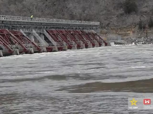
To provide some perspective, the normal water drop in Hastings, Minnesota (see the attached picture), is around 10-11 feet from the top of the lock to the bottom. Right now, the drop in water levels is about 1 foot.
P[L1] D[0x0] M[300x250] OOP[F] ADUNIT[] T[]
So far, locks 1-10 are closed but expect to all be open by May 4. Locks 11 through 18 are closed with no opening dates forecast yet. The Mississippi River at Davenport, Iowa, and Rock Island, Illinois, (lock 15) is nearing record flood stage of 22.7 feet, but the crest is expected to be at 21.6 feet on May 2. However, the river there will be in major flood stage at least through May 8.
Until all closed locks and dams reopen, there will be no barges moving downriver or upriver, meaning commerce on the river at lock 20 and higher remains stopped for now.
WHY AREN'T LOCKS AND DAMS ABLE TO CONTROL FLOODING?
In the approximately 670 miles of river between the first lock at the Falls of St. Anthony area of Minneapolis-St. Paul, Minnesota, and the last lock (No. 27) at St. Louis, Missouri, the Mississippi has a fall of about 420 feet. The U.S. Army Corps of Engineers (USACE) notes that the purpose of the locks and dams is to create a series of "steps," which river tows and other boats either climb or descend as they travel upstream or downstream. Locks and dams on the Mississippi were not built for flood control. Many question why that is not the case.
"There are many reasons why this idea is not practical," said USACE. "The first and foremost reason is that, although they appear to be large flood control structures like a reservoir, locks and dams do not store water; they cannot prevent or cause flooding and they have no flood control capabilities. If the Mississippi River dams could control flooding, that is, hold back or store water, the pool created behind the dam would be so enormous that it would flood many communities.
"Even if each pool (the area between navigation dams) was completely emptied prior to an anticipated heavy runoff period, it would take only a matter of hours to refill them, and this would not appreciably lower the peak river stages reached by the flood. This is because the amount of storage that could be made available by pool drawdowns is extremely small in comparison with flood volumes."
A second reason is that, given the Mississippi River maintains its flow through rain and snowmelt draining into the river from 41% of the continental United States stretching from Montana to New York (31 states and two Canadian provinces), it would be very difficult to lower the river and maintain those levels, notes USACE.
"Reason No. 3 is that there are many other economic and environmental factors as to why we wouldn't lower the navigation pools. Those factors include loss of water intakes for municipal water supplies, manufacturing industries and power generating plants; loss of commercial navigation channel (March 1 onwards); impacts to docks, commercial riverboats (e.g., casinos), and recreational craft; bank sloughing and impacts to levees and shoreline; negative impacts to fish and wildlife habitat; loss of recreational opportunities (fishing, boating, etc.); to name a few," said USACE.
The fourth reason as to why USACE doesn't lower Mississippi River pools is that it is illegal to do so above Lock and Dam 15 in Rock Island in accordance with the Anti-Drawdown Law. This act of Congress, dated March 10, 1934, is entitled, "An act to promote the conservation of wildlife, fish and game, and for other purposes," as amended by Public Law 732 on August 14, 1946, and again by Public Law 697 on June 19, 1948.
On the flip side, remember 2022 when the Lower Mississippi River turned into a sand box and the Upper Mississippi did not? That was thanks to the lock and dam system preventing that from happening.
NWS map of gauges in flood stage: https://water.weather.gov/…
More Lock and Dam info "Why do we have locks and dams?" https://www.mvr.usace.army.mil/…
Mary Kennedy can be reached at Mary.Kennedy@dtn.com
Follow her on Twitter @MaryCKenn
(c) Copyright 2023 DTN, LLC. All rights reserved.