
Commodities Market Impact Weather
More Rain and Severe Weather Early This Week
MINNEAPOLIS (DTN) -- Dryness in the southwestern Plains, wet and stormy weather through the Corn Belt, and patches of dryness in Europe, China, and Australia are the weather factors driving the markets Monday.
MORE HEAVY RAIN, SEVERE WEATHER FOR MIDWEST
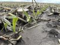
A major severe weather event rolled through the Midwest on Friday with widespread damage and even some areas of blowing dust. Another storm system is rolling through with areas of heavy rain and thunderstorms through Thursday. Southern stretches could see more severe weather occurring with this system. The widespread rainfall should be beneficial for most areas, though some areas across the south are still a little too wet and this will not help that situation. Temperatures will be much colder than normal for most areas this entire week, which could make for some patchy frost under the right conditions. However, that is unlikely to occur or be widespread if it does.
BIG STORM CONTINUES HEAVY RAIN, SEVERE WEATHER THREATS IN CENTRAL AND SOUTHERN PLAINS
Scattered showers erupted across much of the Central and Southern Plains on Sunday, producing areas of heavy rain and severe weather that continues through early Tuesday before the system pushes off to the east. Many areas will welcome the rain, especially in Nebraska that has been so dry, but wheat areas in the southwest will see very little and have trended drier, which may be concerning for filling wheat. Additional disturbances will bring showers through at various points this week and a more concentrated batch of heavier thunderstorms may be possible this weekend into early next week, but models are trying to decide where. Temperatures remain milder, with slower growth for plants, but less stress to areas that remain drier as well.
COLDER WITH BOUTS OF RAIN IN NORTHERN PLAINS
A system moved back into the Northern Plains on Sunday and produced scattered showers, which will continue through probably Wednesday. Heavier rainfall over the last week may have slowed planting progress and some patchy frost was noted over the weekend as well. But the rainfall will be good for early growth. Temperatures are cold this week and we may see some more patchy frost, but damage should be limited. Temperatures should flip warmer after Memorial Day.
P[L1] D[0x0] M[300x250] OOP[F] ADUNIT[] T[]
DELTA CONTINUES TO BE WET
A front brought areas of showers and thunderstorms to the Delta over the weekend as well as some severe weather. Another system will push a front through on Tuesday with more showers and potential severe weather. More rain is expected with another front this weekend and next week. There have only been limited dry days across the region all spring, which has built in a lot of soil moisture, but also caused ponding and flooding for extended periods as well. Though there may be a better stretch of drier weather later this week, temperatures will be much cooler as well, causing drainage of water to be slower.
ROUNDS OF RAIN CONTINUING IN CANADIAN PRAIRIES
A system ended showers over the eastern Canadian Prairies on Friday, but another brought in more to the west and south on Sunday. This system will keep showers going across western areas into Wednesday and more showers may be possible in Alberta to end the week. Recent rainfall may have slowed the rapid pace of planting but should have improved soil moisture for a lot of areas. Those that missed out in western Saskatchewan are forecast to see some decent rainfall this week to help out. Overall, conditions are still largely favorable across the region, though temperatures remain cool for most of this week and may lead to some patchy areas of frost.
FRONT IN SOUTHERN BRAZIL PRODUCING SHOWERS
A front brought showers into far southern areas of Brazil this weekend and will bounce around there throughout the week, offering some more potential rainfall. That is coming mostly for the state of Rio Grande do Sul, a winter wheat state that would enjoy some rain for establishment. Showers may make it into Parana and help filling corn in some limited fashion. Otherwise, the country stays drier, forcing safrinha corn to use up the remaining subsoil moisture.
NORTHERN EUROPE STILL TOO DRY, BUT SHOWERS ON THE WAY
A low spinning in eastern Europe brought widespread showers, including some pockets of heavier rain to parched areas in and around Poland. Though temperatures were also cooler, the rainfall has been overall beneficial and even spread into eastern Germany. That system will continue showers through Tuesday across the east. Another system that moved into Spain on Sunday will move across the Mediterranean with scattered showers this week and we could see more systems moving through northern areas later this week, weekend, and into next week as well. Drier conditions over the last few months have been worrisome for some in France, Germany, and the UK, but multiple chances are starting to show up to bring needed precipitation. They need to hurry for winter crops though, which are getting into reproductive stages of growth.
MORE RAIN FOR BLACK SEA REGION
Streaks of scattered showers continued across the Black Sea region over the weekend and an upper-low in eastern Europe will keep showers going through at least Wednesday. A wetter pattern over the last couple of weeks has been beneficial, but rainfall deficits are still very large in many areas. Though we could see another round of showers across late this week and weekend, the pattern is starting to turn a little drier, especially for southwestern Russia, which may impact winter wheat and emerging corn.
LITTLE RAINFALL FOR AUSTRALIA
Some showers developed across the east coast of Australia over the weekend, but the majority of the wheat belt was dry. That largely continues this week as well though some showers may sneak into the west on Thursday, then into the east on Friday into the weekend. Large-scale dryness and drought continue to develop over some important areas of the country's wheat belt, however, unfavorable for winter wheat and canola establishment.
LIMITED RAINFALL OPPORTUNITIES IN CHINA
Despite some recent rain, drier conditions in central portions of China are stressing wheat and canola that are in reproductive to filling stages. It may also stress some corn and soybean areas that have just been planted as well. A couple of fronts will come through to end the month, but are forecast to produce limited precipitation. Northern corn and soybean areas are in better shape with soil moisture, but have also been very cold, which has likely slowed planting progress. Showers here are also forecast to be more isolated for the rest of the month.
John Baranick can be reached at john.baranick@dtn.com
(c) Copyright 2025 DTN, LLC. All rights reserved.