

Ag Weather Forum
Weather Pattern Change for Second Half of May
Warmth that spread through the U.S. last week favored rapid progress on spring planting. As noted in the USDA Crop Progress Report May 8, corn planting increased 23 percentage points to essentially halfway done while soybean planting increased 16 percentage points to 35% complete.
Spring wheat was slower, but South Dakota was still able to cross the halfway mark as plantings increased by 39 percentage points. Northern areas are still somewhat behind the average pace, but were able to pick it up last week outside of Michigan that stayed cooler and wetter than other areas.
The warmth that helped to kick off the rapid planting is sticking around this week, favoring another week of expected good progress. Anecdotally, as I drove around my area of Minnesota the last couple of days, it appears that just about every field is planted. As any farmer would tell you, good weather does not last for very long, and sure enough we are expecting a change in the weather pattern next week.
Until then, showers will continue to come through much of the country's primary growing regions along with the warmth, which has been falling over some of the drier areas of the Corn Belt since this past weekend. Drought has been a major concern for the Western Corn Belt this spring, but clusters of showers and thunderstorms have been moving through Nebraska and northern Kansas as well as parts of the Dakotas and Minnesota that have been in the longer-standing drought categories since last year. Even some of the more recently dry areas around Iowa, Missouri, and Illinois got some much-needed rainfall since the weekend, helping to improve soil moisture.
P[L1] D[0x0] M[300x250] OOP[F] ADUNIT[] T[]
Although rain has come with severe weather, including widespread reports of significantly large hail larger than golf balls, the wetter pattern for these western states has provided a needed boost to soil moisture for a lot of areas. The rain has not been completely widespread and there are no doubt areas that would disagree with my assessment, but the overall pattern has been wet. Those showers continue to come in disorganized clusters for the rest of the week and into the weekend. A small system will aid that process as it drifts into the Plains on Thursday and then across the Midwest over the weekend. The cold front to the system will not be very cold but be a focal point for continued showers in the Southern Plains through Sunday or Monday, which may bring some heavy amounts to some of the drought areas there.
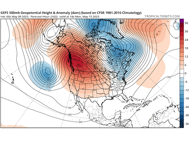
After this weekend though, the overall weather pattern is going to undergo a change. What has been keeping much of North America warm has been a ridge across the eastern half of the U.S. up through the Canadian Arctic. To make the showers, a trough of low pressure has been situated over the West, providing the energy necessary to kick off occasional periods of thunderstorms and small systems.
The trough will make a shift into the middle of the country later this week, hence the small storm system. But after vacating the West, a ridge will pop up there over the weekend, shifting the focus of heat to western North America. At the same time, a trough of low pressure will move down into eastern Canada, bringing a chill to that area that will extend into the Midwest and Northeast as well. The temperature forecast is still being determined, but a move away from above-normal temperatures is expected. That comes with a cold front moving through early next week that may bring some showers, but the period of widespread heavy rain will be over.
The two upper-level systems, ridge in the West and trough in the East will battle over the middle of North America for what looks like the entire second half of May. This sort of battle should remind us of a pattern that promotes clipper systems from Canada. Short bursts of colder air with limited showers should be expected, though temperatures should be variable. Drier conditions are almost certainly to come outside of the Central and Southern Plains, which may stick around in some fashion if we see any disturbances work underneath that western ridge. Though not guaranteed to be widespread or cold enough, the bursts of cold may also bring some frosty mornings to far northern areas of the U.S. and into the Canadian Prairies. That may be hard to accomplish though with systems only briefly carrying the colder air through. Eastern Canada and the Northeast U.S. would stand better chances of that occurring, however.
And of course, nothing is guaranteed. This pattern promotes lower temperatures and less precipitation, but that does not mean that temperatures will be less favorable for planting or growth, or that the drier period will materialize for all areas or lead to issues with soil moisture as planting ends and crop growth picks up.
To find more weather conditions and your local forecast from DTN, head over to https://www.dtnpf.com/…p
John Baranick can be reached at john.baranick@dtn.com
(c) Copyright 2023 DTN, LLC. All rights reserved.