

South America Calling
El Nino May Boost Soil Moisture in May for South American Wheat
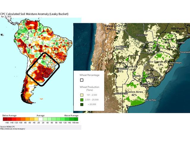
Argentina and southern Brazil have lacked good rainfall during the last several months thanks to a typical La Nina pattern, leading to below-normal soil moisture for much of the region. This happens to be the primary winter wheat growing area of South America.
Corn and soybeans have suffered horribly due to the dry conditions this past season. And as the crop continues to be harvested, reports of low yields and poor quality are highlighting the damage that poor weather has caused in the region. Some rains have moved through, and the northern end of the region in southern Brazil, which is also a large safrinha (second crop) corn growing area, has fared better. Reports from the government of Parana suggest that 10% of the winter wheat crop there is planted and in good condition. However, satellite estimates of soil moisture from the state of Rio Grande do Sul, Brazil south through Argentina highlight a more concerning picture of dryness. That includes the country of Uruguay as well.
P[L1] D[0x0] M[300x250] OOP[F] ADUNIT[] T[]
With such limited soil moisture, the region is going to need showers quickly to condition the soil for planting and emergence before temperatures turn too low, especially across central Argentina.
A front does appear to move through Argentina April 30, with showers limited to about 10 millimeters (0.40 inches) or less for most of Argentina and Uruguay. The amounts are not overly impressive and more will be needed, but it will be a start. Farther north, that front will stall out across Paraguay and Rio Grande do Sul, likely for several days next week. The result could be up to 75 mm (3 inches) of rainfall for these very dry areas. Outside of some risk of flooding, that would be favorable for at least the northern half of the South American wheat belt.
More help may be coming to Argentina and Uruguay in May. Ocean temperatures off the coast of Peru and Ecuador are very warm for this time of year and are indicative of an El Nino.
However, much of the Pacific Ocean is still in the process of warming and neutral conditions are currently analyzed over the entire basin. El Nino favors higher temperatures and increased rainfall across Argentina through southern Brazil, though usually not until summer. The early onset of El Nino in this part of the Pacific Ocean may have some influence over the pattern in the second half of May. After the front brings a cold shot through the region next week, drier conditions will follow as well. But by the middle of the month, models are suggesting that El Nino's influence could start to show up with a bump in both temperatures and chances for precipitation. Should this occur, the prospects for South America's croplands will start making a turn. It was too late to help out corn and soybeans this past season, but may have better prospects moving forward into next season.
To find more international weather conditions and your local forecast from DTN, visit https://www.dtnpf.com/….
John Baranick can be reached at john.baranick@dtn.com
(c) Copyright 2023 DTN, LLC. All rights reserved.