

Ag Weather Forum
Concerns Over the Northern Snowpack for Fieldwork and Planting
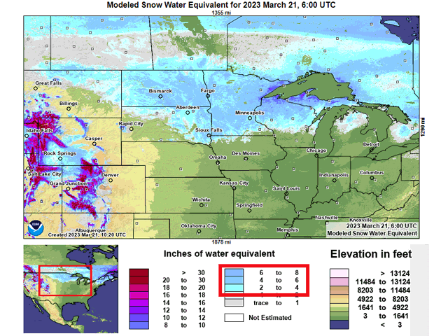
Deep and heavy snowpack has built up during the winter from Montana to Wisconsin. The depth is so great that it is a couple months'-worth of precipitation locked into the snow. Modeled snow water equivalent, or the amount of equivalent amount of water contained within the snowpack, is around 4 to 6 inches over a vast area sitting on top of the soils. Some areas have less and some areas have more, but this 4-to-6-inch range would be the equivalent of an average total for May and June for Bismarck, April and May for Fargo, and March and April for Minneapolis.
There have been some incredible pictures during the winter of large storm systems producing blizzards in these areas that have buried roadways in massive drifts or built huge piles on the ends of driveways and decks. But all that water is going to be released this spring. It is just a matter of when and how quickly.
Obviously, a slower melt would be preferred as that would produce the least amount of flooding and greatest amount of soil penetration. However, if it is too slow, spring planting in these areas would likely be delayed. On the flip side, if the melting is fast, overland flooding would be a likely result and much of this water would runoff instead of percolate into the soils, where drought still exists in for lot of these areas. Therefore, this will end up being a Goldilocks-type of preferred scenario, fast, but not too fast.
P[L1] D[0x0] M[300x250] OOP[F] ADUNIT[] T[]
So, taking a look at the forecast for the next couple of months, what sort of conditions are we likely to see? Well, the active weather pattern that has produced a lot of the snowfall over the winter and early spring remains intact going through April, but that might not translate to a snowier pattern for this area. The preferred storm track will be mostly to the south, which may help to limit additional snowfall into the region. It is unlikely that precipitation does not occur, including as snowfall, for this region however.
But, it will also be a colder pattern overall. That will limit the melting for the next couple of weeks. We have to remember that average temperatures are rising, and even below-normal temperatures could still be well enough above freezing to induce some melting. Overall, this cooler pattern should be preferred, but if it is much colder than forecast, the melting may be too slow.
DTN Long-Range Weather Risk Analyst Nathan Hamblin believes that by the time we get to mid-April, the middle of the country could be looking at a warmup. "The slow warming trend in the North-Central U.S. will keep river flooding at bay for now. If enough snow water equivalent can linger into week four (mid-April), more rapid melting could get area rivers to swell." He did mention that while the risk is greater for higher temperatures for the last half of April, it is not a guarantee. The Northern Plains is still in a spot that could lean colder going into May.
Hamblin's forecast does raise the question about how quickly this year's snowpack will melt. Here is hoping that the weather pattern is at least warm enough to induce some slow, but progressive melting during the next few weeks before warmer conditions speed up the process. It could be a messy situation for northern areas of the country prior to spring planting, but we will continue to wait and see.
To find updated radar and analysis from DTN, head over to https://www.dtnpf.com/…
John Baranick can be reached at john.baranick@dtn.com
(c) Copyright 2023 DTN, LLC. All rights reserved.