

Ag Weather Forum
Soil Moisture Deficits Coming at Bad Time for Pollinating Corn
Scattered showers moved through much of the Corn Belt last week and offered a reprieve from areas that had been too hot and dry, where reports of flash drought were occurring in parts of Illinois and Indiana. The rains did not hit everyone of course, as they rarely do in the summertime, and this week it has been rather dry overall.
Tassels are out on corn and flowers are in bloom on soybeans. We are reaching the most important time of the year for available soil moisture as crops need it to pollinate effectively. That is especially true for corn now. Without proper soil moisture, silking is delayed, silks are less elongated, and embryo development could be affected as well. For soybeans, the effects come later in grain-fill when pods are aborted and seed size is smaller.
Find more information on how corn and soybeans are affected by drought here: https://crops.extension.iastate.edu/… and here: https://blog-crop-news.extension.umn.edu/….
P[L1] D[0x0] M[300x250] OOP[F] ADUNIT[] T[]
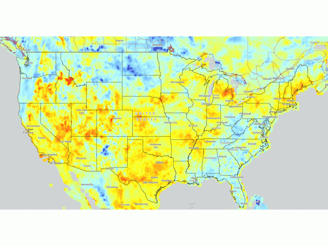
Modeled soil moisture in the top 8 inches of soil from DTN point to very limited areas that are in good shape as the corn and soybean crops get further into reproductive stages. Those areas are mostly in the Northern Plains and Southeast, with other limited areas sprinkled around the Corn Belt. There are more areas with poorer soil moisture, especially with regards to the Central and Southern Plains, but also spread out in areas of northwest Iowa, Michigan, central Indiana, and around the northern Delta. These areas are at risk for adverse effects if showers do not come in earnest. However, it should also be noted that even below-normal rainfall during the pollination period can have positive effects on production.
That brings us to the forecast. A ridge of high pressure in the upper atmosphere is currently located over the western states on July 13. That ridge will spread eastward for the rest of the week and weekend, remaining mostly intact through much of next week. These ridges typically indicate hot and dry conditions. And indeed, under the heart of the ridge in the Central and Southern Plains, the forecast is certainly pointing to that. Temperatures elsewhere in the country will also be well-above normal, with highs in the 90s Fahrenheit and near 100 degrees in several spots of the Corn Belt and Delta on consecutive days. The only thing that would stop the heat would be potential for showers.
A weakness in the ridge in the Southeast will keep daily showers and thunderstorms going, offsetting the heat and being favorable for crop production as long as the rains hit. But the ridge does not extend forever up through Canada. The rim of it will be situated near the Canadian border and it will not be static, it will move around a bit. That will be in part due a trough in the Gulf of Alaska sending pieces of its energy through the Canadian Prairies and along the international border through next week. These pieces of energy should bring enough lift to produce areas of showers and thunderstorms across the Corn Belt, particularly across the north. Eventually, one of these pieces of energy should dig into the Great Lakes and Northeast late next week, putting an end to the heat for the Eastern Corn Belt. Showers that come with it are likely to be limited. Models are currently pointing to quite a bit of excess precipitation for the Eastern Corn Belt. But at this range, models typically overdo how much precipitation actually falls. They have a hard time of concentrating precipitation into thunderstorms until a couple of days before the event. Still, there will be some availability of showers for some areas, which will certainly be helpful for corn in these areas that do get hit.
But western areas are still likely to observe drier conditions and above-normal temperatures through the end of the month and likely into August as well. With the ridge having more of an influence, it becomes much harder for thunderstorms to develop. Dryness and drought concerns will continue to grow west of the Mississippi River. That includes in the Northern Plains, where drought conditions currently do not exist outside a small area in South Dakota and northern Montana.
Indications from the longer-range going through mid-August suggest that the ridge will have more of an impact in the Plains than areas east of the Mississippi River, a situation similar to summer of 2021. However, there are some discrepancies with the forecasts between them, a situation that needs to get ironed out during the coming weeks. I would expect the ridge to be the dominant feature, but that does not mean that a trough cannot sneak its way in from time to time. Hopefully, it will bring some decent rains to widespread areas, but the probabilities are not high for that to occur. Still, as mentioned above, it takes just enough rain at just the right time to get good pollination and a start on early grain fill for corn. Soybeans are still more dependent on rains coming up starting in August. If the pattern can break, like it did in 2021, we could see some decent production even if signs are not pointing to that scenario right now.
To find more regional weather conditions and your local forecast from DTN, head over to https://www.dtnpf.com/…
John Baranick can be reached at john.baranick@dtn.com
(c) Copyright 2022 DTN, LLC. All rights reserved.