
Frost Risks for Spring
April Forecast Includes Potential Risks for Frost in Parts of Corn Belt
The date of the average last frost depends on your location. The farther north you are, the later it is. But local effects can determine your last frost risk as well. Denver has a similar last frost date to Minneapolis, even though it is about 400 miles closer to the equator. The mountains to the west can block airflow and keep air still at night as opposed to Minneapolis where the landscape is relatively flat. The mountains can also keep skies clearer at night than in Minneapolis. The Denver area is also drier, leading to better radiational cooling on most nights.
Radiational cooling leads to quick and sharp temperature drops, sometimes more than you would think is possible. Clear and still nights allow infrared radiation (what most of us would call heat) to escape out to space. Clouds emit infrared radiation back to the earth's surface, keeping it warmer. Winds can churn up and mix the atmosphere. Warmer air well above the surface can be mixed down, keeping temperatures from dropping too significantly. But those calm and clear nights allow temperatures to drop. If they drop to the dew point and it is below freezing, frost occurs.
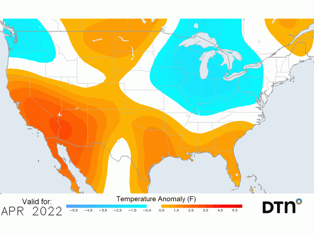
But will 2022 see late frost risks? Well, as with most things in weather, that depends. April temperatures are forecast by DTN to be below normal across much of the Corn Belt. For those southern areas of the belt, there may be an increased risk. But let's look a little more closely at that forecast.
P[L1] D[0x0] M[300x250] OOP[F] ADUNIT[] T[]
For the first couple weeks of April, temperatures should hover right around or slightly below normal for much of the Midwest and even down into the Southeast. A couple of storm systems moving through will bring some colder weather at times. Those that have vulnerable plants are likely to be few but could include winter wheat in some areas.
But around the middle of April, we expect to see a potential shot of cold air moving into the West and Canadian Prairies that should extend through at least the Northern Plains. Our forecasts suggest that this could also spread through the rest of the U.S. somewhere between April 15-21. The intensity of the cold will have to be determined but could potentially produce frosts and cold damage to vulnerable plants. However, at the end of the month, forecasts suggest that temperatures should be above normal, making the cold shot fairly brief.
For early May, the pattern favors more systems moving through that could bring some cold air in. That may or may not be cold enough to produce frosts for the northern tier of the country but could bring some more of those regional radiational cooling events. By the time we get to mid-May, it would be unlikely for the country to see any temperatures low enough for frost damage to occur, limiting the potential for frost damage to mostly wheat, soybeans if planted early, and very few risks for corn.
There are caveats to that forecast, however. One system that is strong enough to tap into Arctic air instead of milder, Pacific air could ruin this forecast in May. It could also be not quite cold enough for a widespread event, but conditions may be just right for strong radiational cooling events. Drier areas of the country farther north stand the best chances for this to occur.
To find more regional weather conditions and your local forecast from DTN, including local frost risks, head over to https://www.dtnpf.com/…
John Baranick can be reached at john.baranick@dtn.com
(c) Copyright 2022 DTN, LLC. All rights reserved.