

South America Calling
Showers, But Below-Normal Precipitation in Brazil
Outside of a couple of stretches of better rainfall in South America since spring, southern Brazil and Argentina have been very dry and crop conditions have suffered. The fate has been sealed on first-crop corn and soybeans in Brazil, and early planted corn and soybeans in Argentina.
The soybean harvest in southern Brazil has passed the 68% mark and first-crop corn harvest has passed 75% according to the Department of Rural Economics in the state of Parana.
In Argentina, the crop is a bit farther behind. The Buenos Aires exchange estimates as of March 17, early planted corn is about 28% mature and 7% harvested, while soybeans are 28% mature but have yet to start harvest.
It's the second-crop (safrinha) corn in Brazil and the late-planted corn and soybeans in Argentina that are the focus for the rest of the season. For Argentina, the season is a bit more limited. Late-planted soybeans are still 22% filling pods and only 1.5% mature. For late-planted corn, the crop is about 32% grain-filling but with none of the crop yet mature.
P[L1] D[0x0] M[300x250] OOP[F] ADUNIT[] T[]
But in southern Brazil, states still have some planting to do. Eighty-seven percent of the corn is planted in Parana and 60% in Mato Grosso do Sul. Development is further along in central states and planting has essentially finished in the central states of Mato Grosso, Goias and Minas Gerais with most of that occurring during the preferred planting window.
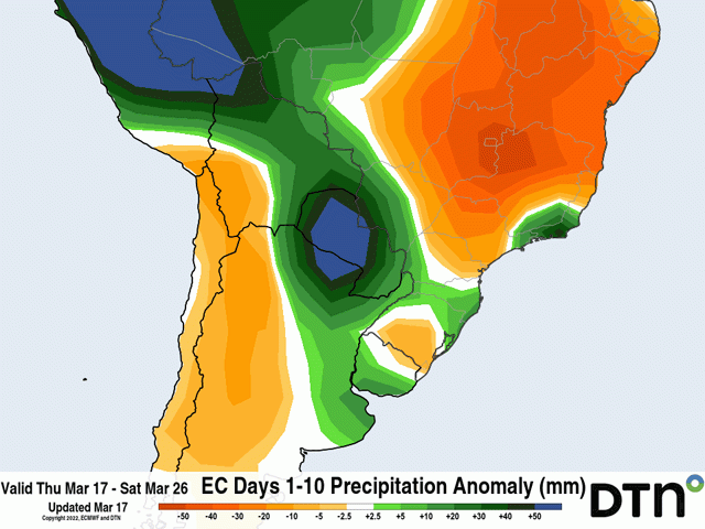
Precipitation during the next couple of weeks is most important then for the Argentine crops as there is limited time for weather to have a stark influence on production. And during the next 10 days, there are a couple of weather systems that will move through. One is currently moving through Argentina March 17-18, but showers look mostly isolated. A few spots will get some decent moisture, but others will be completely left out. Another system will move through early- to mid-next week with more widespread showers March 21-23. Heavier showers will be in northern zones, however, where models are forecasting amounts between 25 and 75 millimeters (one and three inches). That extends into southern Brazil as well, where early growth for safrinha corn has been doing very well.
But showers over central Brazil are anything but normal. The wet season for central Brazil typically starts to wane this time of year with showers becoming a little less frequent and intense with time. However, we are seeing a steeper drop in both the coverage and intensity in the showers in March. Precipitation for the month is already estimated to be below normal through March 15. In some areas, and especially in the states of Goias and Minas Gerais, deficits during the last two weeks have been as much as 50 to 100 millimeters (2 to 4 inches) below normal. Minas Gerais in particular has seen the least coverage and intense showers this month. And that trend is likely to continue to close out March as well.
During the next 10 days, precipitation in Mato Grosso is forecast to be fairly decent between 75 and 200 mm (roughly 3 to 8 inches). For western Mato Grosso, that is above normal rainfall. But in Goias, amounts drop to 50 to 100 mm (2 to 4 inches) and in Minas Gerais it is below 75 mm (less than 3 inches) and some areas across northern growing areas have little-to-none according to the European model.
Limited rainfall will force corn plants deeper into the subsoils and draw more out than is replaced. But this is a time when subsoils should be building or maintaining moisture as the dry season is coming up. In central Brazil, the typical date for the end of the wet season is in the first couple of days of May. However, under La Nina conditions that typically happens a week or two early. The early decline in the showers in March may be the precursor for the wet season ending early again this year. In 2021, the wet season ended in early April. Showers are still being forecast by longer-range models going into mid-April, but are very dry thereafter.
While timely planting has put the safrinha corn crop in a good position to avoid the dry season during pollination for a typical year, an early start to the dry season would force a lot of the crop to rely solely on subsoil moisture for both pollination and grain-fill.
There are significant risks for dryness to continue to affect late-planted corn and soybeans in Argentina and safrinha corn in Brazil. La Nina has not given up its influence or impact just yet.
To find more international weather conditions and your local forecast from DTN, head over to https://www.dtnpf.com/…
John Baranick can be reached at john.baranick@dtn.com
(c) Copyright 2022 DTN, LLC. All rights reserved.