

Ag Weather Forum
Could This Week's Arctic Blast Be the Last Before Spring?
Last week, temperatures rose well-above normal for a good portion of the country. Highs in the 70s and 80s Fahrenheit were common from the Plains to the Southeast. It may have been enough to awaken more of the winter wheat crop out of dormancy as soil temperatures rose.
But that came crashing down in the Plains as a couple of systems moved through and pulled the front to the Gulf of Mexico during the weekend and into early this week where it currently sits. Temperatures behind that front turned lower and have been substantially lower than the previous week. But that is not even the worst of it.
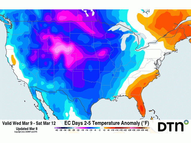
A ridge of high pressure sits off the Eastern Seaboard while another has built up in the Eastern Pacific and into Alaska. With these two features going nowhere for several days, the void in between across much of North America is seeing a deepening trough and cold air draining from the Arctic and northern Canada down into the Prairies and Northern Plains as of Mar. 8. But could this be the last arctic blast of the season? Let us go through the impact of the current arctic shot first.
The front preceding the cold weather will continually push through the U.S. during the course of the next several days. This front will cause significant areas of precipitation for portions of the country. Notably, a band of moderate to heavy snow is forecast along the Nebraska-Kansas border eastward into southern Iowa and northern Missouri for March 9-10 with amounts waning as it works farther east into the Midwest. And then the front will pick up additional moisture from the Gulf of Mexico and spread it from eastern Texas and Oklahoma northeast through the Ohio Valley and all points eastward March 11-12. Another band of heavy snow will occur on the northwestern side of the track, which is forecast to have the heaviest snow in Mid-Atlantic and Northeast.
P[L1] D[0x0] M[300x250] OOP[F] ADUNIT[] T[]
Precipitation will continue to cause wetness concerns for the eastern half of the country that is trying to get some early fieldwork done ahead of spring planting. But the precipitation again looks to skip over the drought areas in the Plains where hard red winter wheat continues to have concerns for having enough available moisture to produce a good crop this season. Current prospects are low.
In addition to the drought, the cold that comes with this blast of arctic air could cause frost damage. Colder conditions during the last few days saw temperature lows in the 10s and 20s Fahrenheit across western Kansas through west Texas, but only for a few hours. The cold that comes later this week should produce high temperatures in the 20s and 30s Fahrenheit March 10-11 with lows in the single digits and 10s. These anomalies are roughly 15 to 30 degrees below average for this time of year.
Low temperatures for that length of time are more likely to cause damage to plants that may be poking their crowns out of the topsoil. On the USDA's assessment of crop conditions in Oklahoma released on March 7, 4% of wheat had reached the jointing stage. At the same time in Texas, 15% of wheat is heading and corn is 18% planted. The cold that comes could have an impact on that portion of the crop.
But is this winter's last hurrah, so to speak? Will we see temperatures this anomalously low for the rest of the spring? Well, at least in the short term, this looks to be it. Models suggest the ridge of high pressure parked firmly in the Eastern Pacific since Jan. 1 is starting to break down. This ridge typically forces cold, arctic air near the North Pole to plunge south into the U.S. We have certainly seen that several times this winter. The ridge has been weakening though for the last couple of weeks as it slowly loses its grip on the overall weather pattern. The strength of it right now is rather impressive, but it is transitory. After the eastern ridge breaks down and allows the trough to pivot out of the U.S. and into Hudson Bay and Greenland this weekend into next week, the Pacific ridge will break down and fill the void across the U.S., bringing in much milder air. That trend looks to continue through the end of March.
That does not mean that the cold air is over, however, or that frost damage concerns are over. Troughs in the Eastern Pacific instead will send pieces of energy through North America and bring some colder anomalies with them. But the extreme arctic cold air may be done. That is, of course, if you do not live in Canada where it is only a stone's throw away. But the anomalies of 15 to 30 degrees below normal could be over for the U.S. once we plow through this event coming upon us.
There is one slight kink in that forecast and that comes courtesy of something called the Madden-Julian Oscillation (MJO). Without going into the specifics, this phenomenon could reinstate the Eastern Pacific ridge in early April and source the cold air out of the Arctic once more.
But according to DTN Long-Range Team Lead Nathan Hamblin, "by early April, the air masses (from the Arctic) don't have nearly as much bite. Also, we'll be reducing snowpack over the northern U.S. and probably southern Canada (over the next few weeks), which will allow for quicker moderation of air masses. While the source region may end up being 'Arctic', the intensity of the cold should not be major like the current shot ... I think the arctic cold is gone." For those of us anxious for spring, this may be it, folks!
To find more regional weather conditions and your local forecast from DTN, head over to https://www.dtnpf.com/…
John Baranick can be reached at john.baranick@dtn.com
(c) Copyright 2022 DTN, LLC. All rights reserved.