

Drier Weather Pattern This Week
Early Harvest Weather Remains Beneficial Despite Active Pattern
Active weather at the end of August was too late to help some of the corn and soybean crop, but put a good dent into the ongoing drought across the Upper Midwest. Much of Minnesota, northern Iowa, the eastern Dakotas, and eastern Nebraska have found relief from the dryness that has plagued much of the area since springtime.
Rainfall was substantial as a front dropped south through Kansas late last week and weekend, helping to ease some dryness in the state and fill soils for winter wheat planting and establishment. The summer dryness has not been overly significant in this region but will become a concern if it continues through the fall.
The active pattern we had been in is taking a breather this week. A system moving through the Great Lakes is bringing some scattered showers through portions of the Midwest Sept. 7, and there may be some severe weather as well. But afterward, the pattern will be a fairly warm and dry one to end the week. This pattern will favor drydown and early harvest of corn and soybeans across the Corn Belt.
P[L1] D[0x0] M[300x250] OOP[F] ADUNIT[] T[]
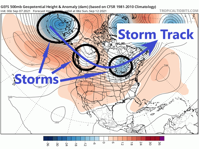
A ridge in the Western U.S. is helping to drive the dryness, but it will not stay there for long. Models indicate that the ridge will slip into the Four Corners region and the northern end of it will weaken. This will allow systems in the North Pacific to move through Canada this weekend through next week, and possibly all of September. While that may mean some better rainfall for the Canadian Prairies, it may also bring some showers to the Corn Belt.
The systems in Canada will slide their fronts through the Corn Belt, inducing some scattered showers. With the low-pressure centers staying mostly in Canada, rains will not be as significant as we saw in August. And the active pattern will keep fronts moving so that showers do not stick in the same area for long periods of time. Unless one of these fronts stalls in a west-to-east orientation when another system moves through, the result should be fairly isolated to scattered showers every couple of days over different areas with relatively low rainfall amounts.
That bodes well for drydown of corn and soybeans despite the occasional rains, especially when you account for temperatures. With the ridge staying somewhat stationary in the Four Corners region or sometimes into the Southern Plains, temperatures will be above normal for most of the country through the month of September, all-things-considered. Sure, temperatures may fall below normal for a day or two as a system moves through, but should pop back up above normal. The above-normal temperatures should also help to dry crops out and allow harvest of summer crops to move through quite well.
The higher temperatures are not all good news, however. Higher temperatures mean an increased demand for moisture for young winter wheat plants. And with moisture chances continuing, but amounts being low, there could be increased drought development in the Southern Plains.
This is likely to be true across the Pacific Northwest as well. Already dealing with intense drought across much of the region, the pattern of mostly above-normal temperatures and limited showers does not make it easy for winter wheat plants to develop good root systems before winter. A difficult 2020-21 growing year for wheat looks like it will continue for 2021-22.
John Baranick can be reached at john.baranick@dtn.com
(c) Copyright 2021 DTN, LLC. All rights reserved.