

Slow-Progressing Corn-Belt Storm
Second System to Move Through Northern States, Then Head South at Week's End
MINNEAPOLIS (DTN) -- Some rainfall across the northern Corn Belt last week had positive effects on corn and soybean crop conditions. Batches of light to moderate rain moved across South Dakota, southern Minnesota and Wisconsin July 6-7 and good-to-excellent crop conditions improved by a few points for both corn and soybeans in all three states.
Of course, the weather story of the week was the strong to severe storms that moved through the Central Plains into the southwestern Midwest July 9-10. Baseball-sized hail and hurricane-force wind gusts ran through portions of Nebraska, Kansas, Iowa, Missouri and Illinois. Heavy, flooding rain in excess of 4 inches was also noted in batches from eastern Nebraska through western Kentucky.
Crop damage did occur, but it is unknown how widespread the damage may have been. There have been some photos of damaged silos, flattened corn, defoliated soybeans and flooded fields. But where some of the strongest winds moved through southeastern Nebraska, crop damage was somewhat limited. Either due to favorable hybrids, deep rootzones, or some other factors, there was sometimes more tree damage than crop damage as noted by my DTN colleague Elaine Shein who took a drive to check on the potential damage.
P[L1] D[0x0] M[300x250] OOP[F] ADUNIT[] T[]
For more information about the severe weather that occurred over the weekend, check out my blog article here: https://www.dtnpf.com/…
With the damage and rainfall coming late in the period, it may not have been fully reflected in Monday's USDA Crop Progress Report, which showed good-to-excellent ratings for corn up 1 percentage point to 65% and unchanged for soybeans at 59%. Though the rainfall was beneficial for some areas to offset those numbers, as well.
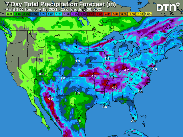
As the weekend storm finally shifts northeast July 13 and 14, another system will quickly take its place. The ridge that has been very stubborn across the West the last several weeks, producing widespread heat records, has shown a few weaknesses at times. One caused the storm over the weekend. Another disturbance is forcing its way through the Pacific Northwest July 13 and will induce another storm across the northern tier of the country late in the day through July 15. Widespread rainfall of 1 to 2 inches is anticipated for South Dakota eastward through Wisconsin -- all areas that are in drought and need more moisture as corn is silking and soybeans are blooming. Some rainfall amounts will likely eclipse the 2-inch mark, most likely from southeast Minnesota and northeast Iowa into Wisconsin on July 14.
The front to the storm system will slowly move southward through the rest of the country this weekend into early next week, continuing to produce moderate to locally heavy rainfall all the way down to the Gulf Coast. The rain will be beneficial for most, but there are some areas that could use a bit of dryness as flooding over the last week has taken a different toll on crops. Good-to-excellent ratings fell on both corn (from 64% to 60%) and soybeans (from 63% to 56%) in Illinois, a state that has been near the epicenter of rainfall over the last 30 days. That epicenter has been northern Missouri, where rainfall over the last month has totaled over 10 inches in many areas. But the rainfall amounts of 4 to 6 inches above normal, and locally much more, across Illinois have waterlogged some corn and soybeans. The forecast of another 1 to 3 inches across the state will only add to woes for those soils that are saturated.
The state is likely to get some relief next week. After the front moves through the region, the ridge across the West will expand northeast into the Canadian Prairies. Temperatures will rise above normal across northern zones, though not dramatically except across the far northwest. But the ridge will mostly shut down precipitation chances for several days. That is a double-edged sword of course. For the saturated soils in the Eastern Corn Belt, some sunshine, heat, and dryness, will all help crops drain soil profiles to more manageable levels. And during the reproductive stages of these crops, conditions will be near ideal. That is not the case for the northwestern Corn Belt. Sure, the rainfall over the next day or two will be beneficial, but it will not be drought-busting. The region continues to deal with the impact of dry soils. The dryness that follows will not be favorable, especially when combined with above-normal temperatures. The pattern of unfavorable conditions northwest and favorable conditions southeast across the Corn Belt continues to be the theme of the season with no end in sight.
John Baranick can be reached at john.baranick@dtn.com
(c) Copyright 2021 DTN, LLC. All rights reserved.