

Best Blog of the Week
Ag Weather Forum: Pattern Change Brings Rain Potential to Corn Belt
The rainfall that occurred in the Northern Plains and eastern Midwest were not enough to increase crop ratings for corn, soybeans, or spring wheat. They were just too isolated and the heat was just too much for crops, including for spring wheat in the Northern Plains.
Scattered showers moved through during the course of last week, and a complex of strong to severe storms moved through the night of June 10 into the morning of June 11. The rain was not enough to reverse fortunes, just maintain poor crop conditions in the Dakotas.
Rain was almost negligible in the central Corn Belt states of Minnesota, Iowa, Wisconsin and Illinois. That really had an impact on corn and soybean good-to-excellent ratings, which fell significantly in all states but by double digits for both in Minnesota and Iowa. These two states suffered the higher temperatures and longer stretch of dryness to combine for the substantial drop in ratings.
I know the fields around my house in south-central Minnesota are not looking good. Soybeans are still in their "ugly" stage and are hard to gauge. But corn, which started to look better as the heat kicked on early to late last week, has started to show curled leaves, indicative of drought stress. My daily drive to get my kids out of daycare has showed me the negative impacts of almost two weeks in the 90s Fahrenheit with nearly no rain to show for it. A farmer was out working his corn field and was kicking up quite the dust storm behind the tractor.
P[L1] D[0x0] M[300x250] OOP[F] ADUNIT[] T[]
The forecast for the next few days offers much of the same around the Corn Belt. The heat continues for the next several days and showers will be quite limited.
A weak frontal boundary will move through the Northern Plains and Midwest through the remainder of the week, but will not have the energy necessary to produce widespread rains. There could be some nice clusters of thunderstorms, including potentially severe storms, but those clusters are not expected to be large or widespread.
The front will put an end to the oppressive heat that has been ongoing across the Plains since the beginning of the month, though temperatures will still remain above normal.
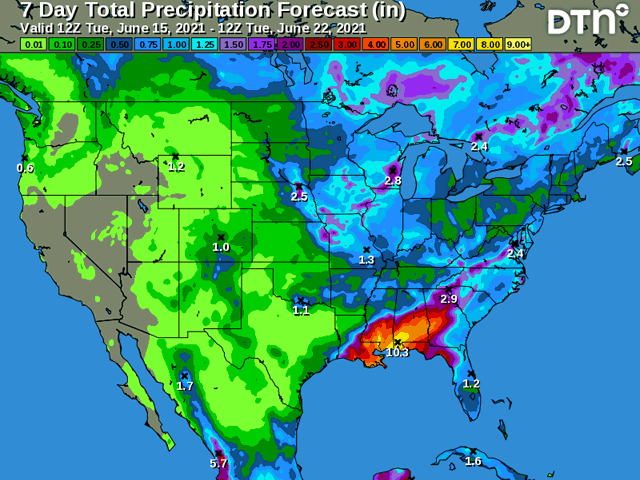
The relief comes in the extended forecast period. A system is likely to move out of the Rockies and across the northern tier of the country June 19-21. This system is forecast by most models to produce widespread moderate to heavy precipitation. I am a little skeptical of both widespread and heavy together. This storm will come with clusters of thunderstorms that move at a decent clip. This will tend to leave some areas with little-to-nothing amounts and make it hard for rainfall to pile up. Models may be too aggressive in the rainfall predictions if you take them at face value.
But there are a couple of complicating factors that could affect this system. One will be the leftover weak front that will likely stall itself out near the Ohio River and back into the Central Plains. This could provide some extra lift and longevity to showers, allowing better rain totals.
The second is a tropical system that is almost certain to form in the western Gulf of Mexico this week. Since this system has yet to even form, as of the morning of June 15, models are likely to change its speed and velocity once the system gets more organized. Depending on where it is and at what time, it could provide additional low-level moisture into the system working across the north. Both factors seem more likely to increase totals across the Eastern Corn Belt. The system may just be moving too fast across the Plains to pick up significant rain.
Behind the system there is another bright spot for dry locations -- cooler conditions. The heat that has engulfed the Northern Plains and western Midwest this month finally looks to break this weekend. Temperatures may only get slightly below normal, but that will help to reduce the impact of the ongoing drought.
And there is one more sneaky feature the atmosphere has to offer the extended forecast and that is an upper-level low developing off the California coast next week. This system could send small pieces of energy into the middle of the country next week, which might be enough to develop areas of showers and thunderstorms.
We will have to watch the models during the next several days to see if this feature materializes in any meaningful way, however. Models are a bit notorious for being optimistic about rainfall chances beyond day seven and this could be a similar situation that just does not pan out. But it is worth mentioning and taking note of, since both the American GFS and European ECMWF models are indicating the potential in today's model runs.
John Baranick can be reached at john.baranick@dtn.com
(c) Copyright 2021 DTN, LLC. All rights reserved.