

Dry Forecast Continues
Dry Spring Featured in Central US Forecast
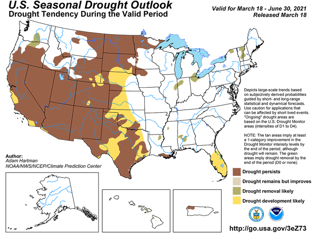
OMAHA (DTN) -- If drought predictions issued March 18 verify, the record-setting rain and snow event across the western and southern Plains during the March 12-14 weekend may not have a long shelf life. Almost the entire Plains region of the United States and a sizeable portion of the northwestern Midwest -- approximately west of Interstate 35 -- are projected to either develop drought or have continued to intensified drought.
That projection does not detract from the significance of from 2 to 4 inches of liquid equivalent precipitation covering a large swath of the interior U.S. from Wyoming and Colorado east to Ohio. In the Plains portion of that swath, "We saw mostly one category (Drought Monitor) improvement, some two-category improvement in Colorado," Missouri State Climatologist Pat Guinan said during a NOAA regional forecast conference call. "Some of those areas had an incredible percent of normal (precipitation) -- 400% of normal in just a few days."
However, there's another record that Guinan noted -- historical winter dryness in the Northern Plains, particularly North Dakota. "North Dakota had its third-driest winter on record," Guinan said. "And it also had the driest September-through-February period on record; that goes back 127 years."
P[L1] D[0x0] M[300x250] OOP[F] ADUNIT[] T[]
Northern state dryness has been enhanced by a very warm spell during the mid-February to mid-March period. "The last 30 days have been very warm -- 9 to 10 degrees (Fahrenheit) above normal in North Dakota," Guinan said. That warmer trend has also kept the Great Lakes from cashing in on a typical winter precipitation feature -- lake-effect snowfall. "There has been a lack of Arctic air intrusion. We haven't seen nearly as much," said Guinan. "And, so, snowfall is quite a bit below normal along the shores of the Great Lakes."
Conditions being warmer and drier highlight the forecast looking through the spring and into the summer seasons as well as over the north-central U.S.
Public and private forecasts call for April temperatures to average above normal. Precipitation shows the greatest potential for favorable amounts in the Delta and Ohio Valley. The April-May-June period focuses precipitation in the Great Lakes and Ohio Valley, with much less moisture farther west.
Summertime is where warmth shows up notably. "All of the country is painted red" to illustrate above-normal temperatures, Guinan said. In addition, precipitation has mainly below-normal totals in northern, western and central areas of the continental U.S. Only the eastern one-third of the contiguous U.S., from eastern Illinois to the East Coast, has above-normal precipitation forecast.
Forecast conference call participant Dennis Todey of the USDA Midwest Climate Hub said that prospects for a drier spring may likely result in earlier corn planting. "We could see earlier-than-average planting to go ahead and get moving," Todey said. "With corn, if you can plant it early, you will -- to get to tasseling before the hot midsummer."
As for the chances of reduced row-crop yields because of summer dryness, Todey said such a decline is possible. "Large chunks of our corn area (will be) going in (planted) with less moisture. That lack leads to less moisture for corn tasseling. Is our risk increased this year? Probably a bit," Todey said.
Bryce Anderson can be reached at bryce.anderson@dtn.com
Follow him on Twitter @BAndersonDTN
(c) Copyright 2021 DTN, LLC. All rights reserved.