

Cash Market Moves
Drought Leaves Many Rivers and Lakes Dehydrated
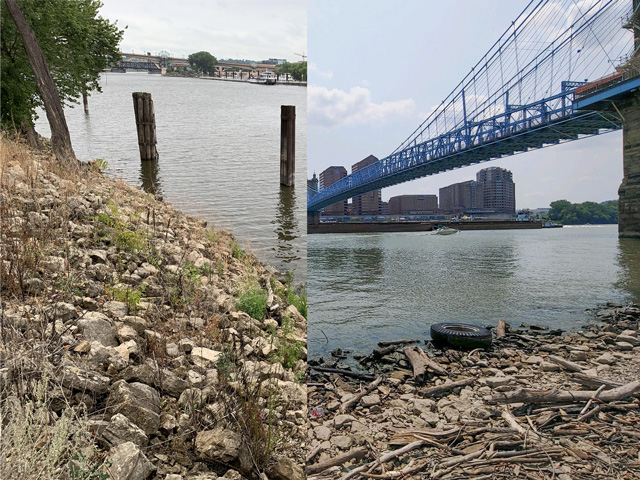
Drought is taking its toll on parts of the U.S. river system as a lack of rainfall has caused exposed shorelines and shallow water in some areas, which could be detrimental to barge traffic if river levels keep dropping.
According to the National Weather Service, on Aug. 8, the Ohio River in Cincinnati was at 26.89 feet (flood stage is 52 feet); the Mississippi River in downtown St. Paul was at 3.53 feet (flood stage is 14 feet); the Mississippi River at St. Louis was at 6.07 feet and is forecast to fall to 2 feet by Aug. 21 (flood stage is 30 feet); the Mississippi River at Memphis is considered to be in low-water stage at 2.5 feet and is forecast to fall below zero gauge by Aug. 21 at -1.4 feet (flood stage is 34 feet), and the Mississippi River at Vicksburg was at 18.97 feet and is forecast to fall to 15.5 feet by Aug. 21 (flood stage is 43 feet).
When the rivers become dangerously low, low-water advisories will be issued and will include cutting drafts on barges to avoid groundings on sand bars and/or barges hitting exposed rock pinnacles. Back in 2012, when the drought significantly dried up the Mississippi River, the Army Corps of Engineers spent much of the late fall dredging and blasting rock pinnacles south of St. Louis, slowing and/or stopping barge traffic heading to the Gulf.
A normal draft -- the distance between the waterline and the deepest point of the boat -- for a barge when river conditions are good is about 12 feet at 1,500 tons. On the Illinois, barges are regularly loaded to about a 9-foot draft at 900 tons. Each foot of draft that is reduced means a barge's cargo is cut by 200 tons and will cost shippers money as they are paying the same amount of freight to ship less.
The U.S. Army Corps of Engineers, St. Paul District, is continuing to closely monitor water levels on the Upper Mississippi River across Minnesota, Wisconsin and Iowa. The low water so far is not affecting shipping conditions on the river and navigation continues.
"Low flow is exactly the conditions for which the locks were built," said Dan Fasching, St. Paul District water manager for the Upper Mississippi River. "The locks, combined with dredging efforts, are used to maintain navigable depths in the main channel."
P[L1] D[0x0] M[300x250] OOP[F] ADUNIT[] T[]
The St. Paul District Corps is also closely monitoring water levels at its Red River of the North reservoirs. "Below-average precipitation and drought conditions continue to impact reservoir levels and discharges," noted the Corps. "Recent scattered precipitation in the basin has generally kept the pool elevations level, but the Corps will continue to assess conditions and if releases need to be made and/or increased."���
Thomas Russell, Russell Marine Group, said that areas on the Upper Mississippi will be dropping as forecasts call for dry conditions in the Midwest. "While there are no delays or slowdowns currently, water stages on Upper Mississippi should be monitored during August. The center areas of Lower Mississippi have low water readings but there are no navigational delays or slow-downs as of now."
LAKES AND STREAMS AFFECTED BY DROUGHT
As the drought continues to affect the Western U.S., many streams and large lakes are shrinking. Perhaps the most well-known is Lake Mead, a Colorado River reservoir just east of Las Vegas on the Nevada-Arizona border. According to CNN, the lake, "is poised to become the focal point of one of the country's most significant climate crises: water shortages in the West. Millions of people will be affected in the coming years and decades by the Colorado River shortage alone, researchers say, with some being forced to make painful water cuts."
In Las Vegas, 90% of their water comes from Lake Mead. Currently, Lake Mead is experiencing record-low water levels (http://mead.uslakes.info/…).
According to the Associated Press, a new Nevada law in June outlawed about 31% of the grass in the Las Vegas area in an effort to conserve water amid the drought. "Other cities and states around the U.S. have enacted temporary bans on lawns that must be watered, but legislation signed June 4 by Gov. Steve Sisolak makes Nevada the first in the nation to enact a permanent ban on certain categories of grass," noted the AP.
The ban targets what the Southern Nevada Water Authority calls "non-functional turf." It applies to grass that virtually no one uses at office parks, in street medians and at entrances to housing developments. It excludes single-family homes, parks and golf courses. "The ban came as the seven states that rely on the over-tapped Colorado River for water -- Arizona, California, Colorado, Nevada, New Mexico, Utah and Wyoming -- reckon with the prospect of a drier future," according to the AP.
Lake Mead and Lake Powell, the second-largest reservoir in the U.S., are the two reservoirs where Colorado River water is stored and nearly all the Upper Colorado River basin is experiencing severe or extreme drought.
According to AP, both Lake Powell and Lake Mead are projected to fall this year to levels that would trigger the region's first-ever official shortage declaration and cut the amount allocated to Nevada and Arizona.
To say the situation is dire would be an understatement.
Mary Kennedy can be reached at mary.kennedy@dtn.com
Follow her on Twitter @MaryCKenn
(c) Copyright 2021 DTN, LLC. All rights reserved.