


ND Farmer Challenges Wetlands Map
Wetlands Easement Lawsuit Could Affect Farmers Across Prairie Pothole Region
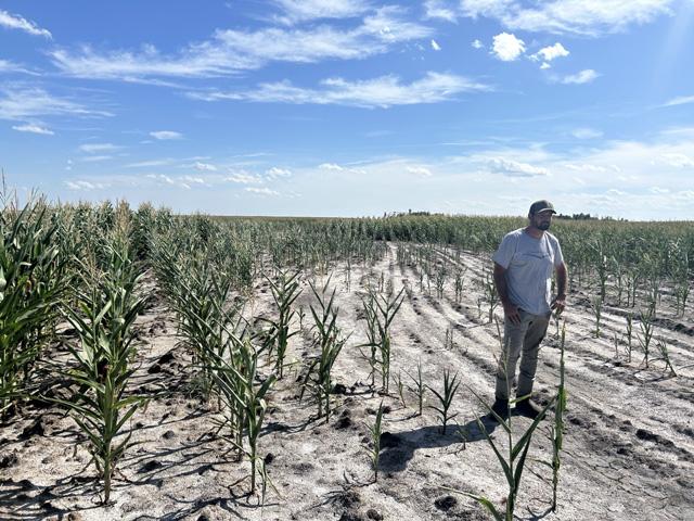
LINCOLN, Neb. (DTN) -- The soil is rich, but the landscape of LaMoure County, North Dakota, is challenging.
Farmer Cody Peterson lives it.
Working the land in the prairie potholes isn't for everyone, but Peterson embraces its demands.
He loves the wetlands, wildlife and all the work needed to conserve them.
Yet Peterson says the future of his operation is in question.
The turning point came on Feb. 24, 2020, when he received a revised wetlands waterfowl production area easement map for his farm from U.S. Fish and Wildlife Service.
USFWS expanded acreage covered by the 1963 easement and claimed broader control over what the agency deems as protected wetlands on Peterson's farm.
Suddenly, he faced the difficult prospect of being unable to install much-needed drain tiling to effectively grow crops.
Now the economics for his operation are even tougher.
"I can't make big money for rent," Peterson told DTN.
"I want to take my land and make it better. And then, when we are being the most efficient we can on our acres, you don't have to have so much to make a good living. When I'm done in 50 years, I want to have something that I can give to my family."
USFWS mapped about 41 wetland acres on the disputed tract, while a Peterson consultant concluded the historical wetland acreage was about 35 acres -- a difference of about six acres.
The dispute isn't entirely centered on the total number of acres, according to a 2025 federal lawsuit Peterson filed in the U.S. District Court for the District of North Dakota.
In fact, Peterson has argued USFWS mapped one wetland area at seven acres when it should be closer to 15. Instead, the lawsuit is about which specific acres are protected and where the boundaries are located.
For example, Peterson said corn yields in one section are some 40% to 50% lower because of a lack of drainage from the field.
"I'm planting these salt spots, I'm maintaining these salt spots, but I'm not getting a yield out of them," he said.
"Some of the salt spots go into the wetland setback and some of them don't, but it just, you can't go physically like drain tile this stuff because you don't know where you can and can't go."
His lawsuit alleges the USFWS map violates the law because it protects wetlands that didn't exist when the easement was signed, that it relies heavily on aerial photos taken decades after the easement and uses standards from a 2016 agency manual rather than the original easement contract.
FEDERAL PROTECTIONS GROW
In addition, Peterson argues the agency maps acreage the Petersons have historically farmed and expands federal easement protections beyond what the original landowners intended.
Peterson filed a formal objection to the map on April 3, 2020, arguing that USFWS should base the easement on wetlands that existed when the easement was purchased in 1963 and not on wet areas that appeared later on his farm.
P[L1] D[0x0] M[300x250] OOP[F] ADUNIT[] T[]
He argued that many disputed areas on the new map had been farmed for decades and that USFWS lacked evidence of historic surface water, and that other wetlands were incorrectly sized or drawn on the map.
Peterson asked the agency to redraw the map to reflect what they believed historic aerial photos show was present on the farm.
Less than a month later, USFWS rejected most of the objections, and Peterson appealed to the regional director on May 28, 2020. The director sided with USFWS in July 2020.
Five years later, Peterson filed a federal lawsuit.
"And through all the stuff I've submitted to them, the response you get is, 'nope, this is that,'" he told DTN.
"'This is how it's going to be. Sorry, there was an easement sign. That's how it is.' I don't think most people realize it, but if I went out and drained this so-called wetland of fish and wildlife, it is a federal offense and I get thrown in jail."
DTN reached out to USFWS for comment.
PETERSON STORY NOT UNIQUE
The Peterson story is not unique in the prairie pothole region.
Jeffrey McCoy, a Pacific Legal Foundation attorney who represents Peterson, told DTN the federal approach to wetlands in the region has many farmers and ranchers on edge -- fearful about the potential consequences in managing USFWS easements in a challenging farming environment.
"There have been dozens of farmers that I've talked to that are in a similar situation," McCoy said.
"He, like other farmers, were very conservative, took a very conservative approach to these wetlands because they didn't want to go to prison."
The potential scope of easements affecting farmers in the state is broad.
As of 2020, the USFWS held about 15,000 wetland easements in North Dakota protecting about 994,000 acres of wetlands, according to an October 2021 study by the North Dakota Legislative Council.
NIGHTMARE SCENARIO
Since about 1997, the region has been in a wet cycle that has led to nightmare scenarios for farmers.
Peterson recalled a situation his brother faced when flooding threatened his farming operation -- as another example of the challenges in the prairie pothole region.
His brother bought a farmstead and built a house on the property in the 1970s.
USFWS leased a 3.7-acre slough some 300 or 400 feet from his house built on a hill, and he started losing grain bin foundations as waters rose. Peterson said his brother had to move grain bins, break up foundations and build new ones, and he had to drain tile around his basement.
"So everything has just gotten wetter, wetter, wetter and wetter," Cody Peterson said.
"We couldn't drive into his yard because the ground was so saturated. You were pretty much sinking in one foot everywhere you went on it. And when he asked Fish and Wildlife, 'What can we do? Can we do something just to get this better? We got told, 'No, sorry, there's an easement on, there's nothing you could do.'"
Peterson said he and his brother dug the slough and drained it. USFWS allowed the slough to be temporarily drained but required it to be restored.
Eventually USFWS allowed his brother to buy out the 3.7-acre easement, but in the end he spent hundreds of thousands of dollars to save his farm.
"He had to pay $3,300 an acre," Peterson said.
"You add up my 1,000 acres of easements, they don't even hit $2,500. That's crazy. He had to buy that out for $3,300 an acre. Now ask yourself this: how much capital gain taxes do you think fish and wildlife paid on that? Because I sure as hell know I would have had to."
POTENTIAL EASEMENT SOLUTIONS
McCoy told DTN steps can be taken administratively to make life easier for farmers and other landowners in the prairie pothole region.
That includes convincing USFWS to change its interpretation of easements and its 2024 drain tile setbacks rule.
On July 24, 2026, the USFWS opened a 14-day comment window on the rule and received more than 200,000 comments. On Aug. 14, 2026, the agency announced it would take no further action while it reviews the comments.
That rule essentially shifted how agricultural drainage is regulated around federal easements -- moving from an agency guidance approach to legally codified regulations.
It set into law that USFWS use a uniform set of data in calculating setback distances, including soil characteristics and hydrology, field topography and slope, as well as specific depth and diameter of drain tile being installed.
The rule also locked in a so-called "no-impact" standard to protect shallow prairie potholes. It limits subsurface tile drainage to a maximum of 1.2 inches of incidental water drawdown in a 14-day window.
In addition, McCoy said the solution also lies in how courts enforce existing property laws as well as federal agencies using standards that are consistent with those used by the Natural Resources Conservation Service.
"If you do something that has a minimal effect on wetlands that doesn't drain it or drastically change it, then it doesn't run afoul through those regulations," he said about the NRCS approach.
"We think it would be appropriate to align their standards with NRCS standards. It's a balance between protecting these wetlands and farming. NRCS, their regulations, I think strike a correct balance."
When it comes to Peterson's lawsuit, McCoy said he hopes the court rules the map doesn't follow the law and requires an agency re-do.
"We would hope that they would say that that's not the standard reflected in the easements or in the law of property," McCoy said.
"We think especially with the 2024 rule, if we get a good decision on that, would help farmers across the state because they would have less stringent rules on this."
In the meantime, Peterson said he continues to look for ways to keep the farm profitable while making it possible for his family to stay in agriculture years from now.
"I've done so many things to try to get this land productive again," he said.
"All it takes is one wrong rain and it goes backwards. I mean, I've changed my farming practices. Everybody knows there's no money in wheat. We raise wheat on a lot of this ground because it actually grows there. So I mean, I'm sacrificing dollars to try to get my ground better because I'm a farmer.
"When one side is so bullheaded, you might as well just go beat your head against the wall."
Todd Neeley can be reached at todd.neeley@dtn.com
Follow him on social platform X @DTNeeley
(c) Copyright 2026 DTN, LLC. All rights reserved.

