
Ag Weather Forum
NOAA Report Asserts Texas Wildfire Outbreak Influenced by Climate Factors
A post on NOAA's website https://www.climate.gov/… titled "Climate Context of the February 2024 Megafire Outbreak in Texas" offers a detailed look at how seasonal climate patterns and relentless warming tied to greenhouse gas emissions in the atmosphere combined to create the conditions for the record-setting fire outbreak in the northern panhandle of Texas during the last week of February.
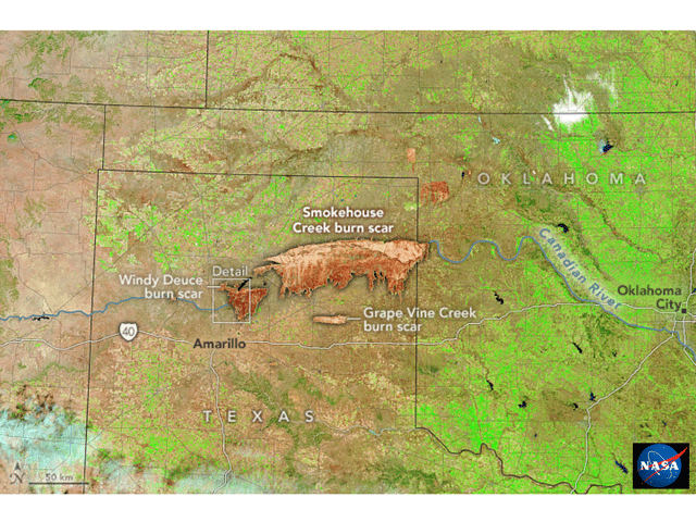
The report is authored by NOAA climate.gov journalist Rebecca Lindsey with input and reviewed by Todd Lindley, a NOAA forecaster who specializes in fire weather on the Southern Plains. The term "megafire" is used for fires larger than 100,000 acres. The fires in late-February/early March have already charred beyond that. As of March 11 morning, the Smokehouse Creek Fire was estimated at 1,058,482 acres (89% contained), and Windy Deuce Fire at 144,405 acres (94% contained), according to Texas A&M Forest Service. (https://tfswildfires.com/…)
The report notes the Texas Panhandle fires occurred at the prime time of the year for fires in the region. The southern Great Plains fire risk historically is highest in late winter and early spring, when grasses are dry and have not broken dormancy, but temperatures are starting to climb.
A peculiar aspect of the 2024 fire outbreak, however, is that this event occurred during an El Nino winter season which featured above-normal precipitation and no assessment of drought in effect in the area on Feb. 26 when the fire outbreak started. Fire potential typically is greater in years with a Pacific Ocean La Nina pattern, which is associated with dry conditions in the Southern Plains. However, NOAA Southern Plains fire forecaster Todd Lindley noted that El Nino-related precipitation allowed more vegetation growth and effectively increased the fuel supply for the fires.
"You grow more grass, and then you get into the winter and (early) spring dormant season, and those fine fuel loadings are vulnerable to fires," Lindley said.
Even with that extra growth, Lindley and other fire forecasters were surprised at how rapidly fire conditions developed in late February. An index forecasters use to estimate the condition of vegetation and how much heat it could release if burned soared from below the 50th percentile on Feb. 21 to above the 80th percentile on Feb. 26 -- a huge increase in less than a week.
P[L1] D[0x0] M[300x250] OOP[F] ADUNIT[] T[]
Fire suppression and the introduction of plants with explosive fire-fuel potential also played a part in this fire outbreak scene. Across the western U.S., programs to reduce the occurrence of rangeland fires have been in place during the past century. Lindley noted, "The fire suppression has allowed an invasion of short, woody species like eastern red cedar and mesquite." This, in turn, has led to a mixed ecosystem, where fires are spread by the grass fuel, but can then reach high intensity when burning reaches the low-canopy wooded plants.
The post also features extensive detail on how long-term global warming contributes to the tipping of the atmospheric and environmental scale toward more severe fire weather. The fire weather summation from the Fifth National Climate Assessment is highlighted below.
"From 2000 to 2018, firefighters in the Southern Great Plains fought 16 megafires -- fires that encompass over 100,000 acres, overwhelm local response capacity, and are extinguished only when weather conditions become favorable. These fires are associated with extremely dry vegetation, unusually warm temperatures, and strong winds aloft -- conditions projected to become more prevalent as the region warms and soil water evaporates more quickly."
From the NOAA National Centers for Environmental Information (NCEI) U.S. Climate Summary for February 2024: The Smokehouse Creek wildfire burned more than a million acres in the Texas Panhandle and western Oklahoma. The wildfire began on Feb. 26 and has become the largest wildfire in Texas history.
February 2024 was the third-warmest February on record for the nation and precipitation ranked in the driest third of the historical record for the month.
The Rebecca Lindsey post concludes with details on the importance of fire mitigation and adaptation efforts to cope with the increased frequency and intensity of fire outbreaks in the Southern Plains. Climate scientist Katharine Hayhoe of Texas Tech University offered a comment on this sub-topic, a portion of which is contained here:
"We've neglected the long-term consequences of our management practices, and the consequences of that choice are affecting us today. It's time to consider both the near-term and the longer-term benefits of natural climate solutions including smart grazing, ranching, and farming practices."
The full NOAA "Climate Context of the February 2024 Megafire Outbreak in Texas" report is available here: https://www.climate.gov/…
The NOAA NCEI February U.S. Climate Summary may be found here:
Editor's Note:
See DTN's coverage of the wildfires at https://www.dtnpf.com/…
See how to help wildfire victims or to access resources at https://www.dtnpf.com/…
Bryce Anderson can be reached at Bryce.Anderson@dtn.com
(c) Copyright 2024 DTN, LLC. All rights reserved.