
Ag Weather Forum
Where's The Cold Air From These Clippers?
We have rarely mentioned clipper systems this winter, but they are going to be moving through the country this week and possibly next week as well. When the term "clipper" is mentioned, it usually brings about thoughts of stripes of precipitation, usually a small band of light to moderate snow, strong winds, and a quick change to colder temperatures. The pattern is set up for clippers this week as well as most of these features, but not the usual cold. Why is that? I guess you could blame El Nino once again.
First, we have to understand how and why clipper systems form. A clipper system usually requires an upper-level ridge in western Canada -- preferably up into Alaska -- as well as a trough over Hudson Bay or eastern Canada. That is not always the requirement, but it is the preferred and most-common mechanism.
Little disturbances that ride around in the upper levels then move between the two, starting up around Alberta and diving down into the Great Lakes. Upper-level winds are usually pretty fast, and the storm moves quickly. Hence the term Alberta Clipper. The path doesn't always follow that trajectory, but it is the most common.
When storms follow this path, they do not have access to a lot of moisture, and their speed does not allow for moisture to come up from the Gulf of Mexico to aid in development of precipitation. This means they usually produce streaks of precipitation where lift is the strongest, instead of vast shields of precipitation. They can still be strong, though, and when it comes from Canada, it is tapping into enough cold air during the winter to put down a narrow band of heavier snow. Two to four inches is common but sometimes these bands could lay down over a foot! It just depends on speed and available moisture.
Winds with these systems are usually intense for three reasons. One, because of the rapid development of the low-pressure center from the storm. It usually deepens quickly and rapid changes in pressure force air to move quickly. Two, also because of the high upper-level winds and quick forward speed of the storm. Three, it's usually followed by some cold air. A rapid change in temperature also leads to stronger winds.
P[L1] D[0x0] M[300x250] OOP[F] ADUNIT[] T[]
Coming down from northwestern Canada, these systems tend to pull down some pretty cold air, especially during the winter. Out ahead of these systems, it is generally pretty warm -- at least compared to normal. The quick replacement of air results in a rapid drop in temperature from the front side of the storm to the back side and areas like western Canada, the Northern Plains, and Upper Midwest are usually in line for some significantly below-normal temperatures. Drops of 40 to 50 degrees have been known to occur; but in general, 20- to 30-degree drops in high temperatures from one day to the next are pretty common.
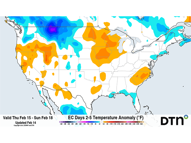
Looking at the setup for this week, the only thing missing is the cold air. As of early on Feb. 14, a clipper has moved down through the Canadian Prairies and is currently moving into western Ontario. The track of the primary low is a bit farther north than usual. But the cold front that is set up in South Dakota will be producing a new low-pressure center Wednesday and it will track eastward into the Great Lakes for Thursday. The system has already started to form a narrow band of snow across South Dakota that should move eastward with the new low. Amounts are being forecast around 8 inches in parts of South Dakota as the storm gets going, but more like 2 to 5 inches as it moves eastward through southern Minnesota through Michigan.
But the winds are not strong currently. That is mostly because the storm is developing a new low center. Once that gets going, forecasts in the Great Lakes for Thursday are for gusts in the 30- to 40-mph range, pretty typical of a clipper. So eventually we'll put a check on that. But it's the temperatures that are not all that impressive.
Early Wednesday morning, temperatures did reach down into the single digits above and below zero in parts of the Canadian Prairies. But that is largely because winds were calm and skies were relatively clear, not because of cold temperatures coming from northwest Canada. In contrast, it was in the 10s above zero in northern Alberta this morning, not exactly a cold temperature for them this time of year. Ahead of the developing clipper, temperatures were in the 20s and 30s and, even around the Northern Plains, the difference in temperature ahead and behind the cold front was only about 10 degrees. As the system gets going for the next couple of days, temperatures will fall behind the clipper, but only by about 10 degrees.
We will see another clipper forming shortly after that one with a track farther south. This one will develop around Wyoming and northern Colorado and move east-southeast into the Mid-Atlantic Friday into Saturday. This system also checks off most of the boxes for a clipper. Though it is pretty far south it will move very quickly through the U.S. It will contain streaks of light to moderate precipitation, including some snow from Wyoming to Maryland. And it will produce wind gusts in the 20- to 30-mph range, a bit less than typical. This time, the cold front will basically sweep through the southern tier of the country and wipe out the current warmth noted in many of these areas. But temperatures still won't be all that cold. Nashville is forecast to go from a high of 60 on Friday, to a high of just 43 on Saturday. Atlanta will go from 66 on Friday to 56 on Saturday. Dallas will go from 71 on Friday to 51 on Saturday. A drop of 10 to 20 degrees is not necessarily a big drop in temperatures. Noticeable, sure. But nothing drastic. So why are we not going to see a huge plunge of Canadian or Arctic air into the U.S. this week?
You could blame El Nino for that -- at least to some degree. The setup in the upper levels is pretty good with this northern jet stream to get the clippers to develop. We have a ridge in western Canada that is poking up into Alaska and a trough developing around Hudson Bay. The only problem with getting cold air into the U.S. is the southern jet stream is also active. During an outburst of clippers, it is usually this northern jet stream that is the dominant one. But during El Nino, the southern jet stream is usually the more dominant. It floods the country with mild, Pacific-sourced air and blocks the real cold up into northern Canada. At the same time, we have these clippers moving through, the southern jet stream is pumping in that mild air. And even after these cities take a dive on Saturday, the Pacific air pops those temperatures back up the next day.
The setup is still good through next week, though probably farther north with the systems. Canada looks like it will be busy. But the southern jet stream is just too powerful. After the quick burst of snow and seasonably cool air for Friday through Sunday, depending on the location, temperatures go right back above normal next week. Northern areas and those in the Plains will see the quickest turnaround. Those in the Southeast may have to wait an additional day or two. But the El Nino pattern just will not give up this winter. Any thoughts about significantly cold air have been just dreams in the long-range forecast. Outside of that significant burst of arctic air from the polar vortex in mid-January, cold air has been hard to find for most of the country.
**
To find more weather conditions and your local forecast from DTN, head over to https://www.dtnpf.com/…
John Baranick can be reached at john.baranick@dtn.com
(c) Copyright 2024 DTN, LLC. All rights reserved.