

Ag Weather Forum
Heat Ridge Shifting West, Offering Colder Temperatures East Temporarily
A ridge of high pressure in the upper atmosphere has been responsible for some intense and record-breaking heat east of the Rockies over the last 10 days or so. It has not been a consistent feature except in the Deep South and Southeast, where temperatures have regularly eclipsed normal highs with high levels of humidity as well, stressing crops and livestock in kind. But the ridge will start to make a move westward this weekend, bringing heat to the Rockies and West Coast. The biggest question is: Will this be a temporary shift? Or has the long-range forecast changed to a cooler look east of the Rockies?
While the ridge has not kept temperatures consistently high across the north, owing to troughs of low pressure moving through Canada and sending cold fronts south through the Corn Belt, when the heat has been on, it has been oppressive.
Minneapolis, Minnesota, reached a record high of 101 Fahrenheit on June 20, the city's first triple-digit temperature since Memorial Day in 2018. Chicago's O'Hare International Airport fell just shy on June 21, reaching a high of 99 Fahrenheit, though not-far-away Rockford, Illinois, did reach the 100-degree mark. According to the National Weather Service office in Romeoville, Illinois, the last time either of these two sites hit triple digits was in 2012. Farther south throughout the Midwest, Central and Southern Plains, and down to the Gulf of Mexico, triple-digit temperatures have become relatively common, and the heat has been record-breaking in a lot of areas on consecutive days.
After a cold start to the growing season across the north, the heat was initially welcomed by producers to get their late-planted crops back toward the normal pace. It worked, with the USDA on Tuesday indicating both corn and soybean emergence have reached back up to the five-year average after being slightly behind over the last few weeks. And outside of North Dakota and parts of Minnesota, emergence for spring wheat has also been brought back up to normal.
P[L1] D[0x0] M[300x250] OOP[F] ADUNIT[] T[]
That latter point is important because soil moisture continues to be good for most of the Dakotas and improved drastically over the last ten days in Montana, lifting the good-to-excellent rating for the crop from 15% to 25% in that state over the last week. Rains early this week likely made additional improvements there. When combined with above-normal temperatures, the increased soil moisture leads to quick and healthy crop growth.
Back to the heat, our central ridge remains firm for this week, but it is going to do some shifting around. A pair of troughs are found in the West on June 22 -- one in the Southwest and one moving into British Columbia, Canada. The northern one will absorb the southern one in the next couple of days, deepening across central Canada over the weekend and then across the eastern U.S. early next week. That will push our ridge back to the west, being located over the Intermountain West and bringing the heat to that area of the country for several days.
Wheat and other crops in the Pacific Northwest have been enjoying much improved rainfall and soil moisture over the last couple of months, with rain reducing or eliminating long-standing drought for most of the region. Good-to-excellent crop ratings for both winter and spring wheat are high, above 70 percentage points for Washington, Oregon and Idaho. But the troughs that have brought the showers have also kept the region cold and development has been behind. Winter wheat headed was rated at 67%, 97%, and 44% for Washington, Oregon, and Idaho, respectively. The averages for each state are 93%, 98%, and 80%, respectively, making Washington behind by 26 percentage points and Idaho behind by 36 percentage points. With the improved soil moisture, the incoming heat will help these crops catch up. That is as long as the heat does not melt the above-normal snowpack in the region too much. Flooding may be a concern with these incoming temperatures.
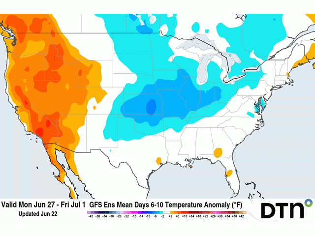
With the ridge anchored in the West, the door is open for cold fronts to penetrate farther south and bring cooler air across the East, though that term is relative for this time of year. High temperatures may fall 10 to 15 degrees Fahrenheit below normal, putting highs in the 70s and 80s instead of the 80s and 90s. And temperatures will still warm up ahead of these fronts coming through, so the cooler temperatures will not be consistent, especially across the south where it will be more difficult for fronts to maintain their coolness before moderating quickly.
While fronts may make it through more of the country, that does not mean precipitation is more likely or heavier. Being focused on the interior East, the troughs do not have access to a lot of upper-level support or moisture except for the East Coast. While fronts will go through and produce showers, they are unlikely to produce widespread clusters of thunderstorms. Instead, those clusters will be more isolated, leaving more areas wanting than those that get good rainfall.
The question though, is, how long would this last? Recent long-range model runs of both the American Global Ensemble Forecast System (GEFS) and European Centre for Long-Range Weather Forecasting (ECMWF) bring that ridge back into the Plains in early July, though there is some waffling around through the month. When the ridge moves a little eastward, the eastern trough will also be shoved off the East Coast, bringing more heat back into the country and also keeping it drier. When it moves west, there is more of an opportunity to bring cooler temperatures into the U.S., especially in the Northeast and Great Lakes, and a little bit of rain relief. But when all is averaged together, a hot and dry July is still being forecast for most of the country. The details are just starting to become a little clearer about how that will come to fruition. There will likely be nuances to this hot and dry pattern, as small-scale factors and disturbances cannot be forecast until a few days out. But overall, the large-scale forecast is not changing. The cooler forecast for the end of June does not mean July or August will be cooler.
To find more regional weather conditions and your local forecast from DTN, head over to https://www.dtnpf.com/…
John Baranick can be reached at john.baranick@dtn.com
(c) Copyright 2022 DTN, LLC. All rights reserved.