

Ag Weather Forum
Officially Official, La Nina has Developed
Well, it is now officially official. While the Climate Prediction Center (CPC) in the United States declared a La Nina state in the tropical Pacific Ocean about a month ago toward the end of October, the Australian Bureau of Meteorology (BOM) had held off, waiting for conditions to be more definitive. On Nov. 23, however, the Bureau updated its outlook and declared La Nina conditions in effect.
According to its outlook: "La Nina has become established in the tropical Pacific. The Bureau'sâ?¯ENSO Outlookâ?¯has been raised to LA NINA. Climate models suggest this La Nina will be short-lived, persisting until the late Southern Hemisphere summer or early autumn 2022."
The CPC and most models generally agree that La Nina conditions will be brief, lasting only a few months while peaking around the first of the new year and then generally falling back into a neutral state in Northern Hemisphere spring, or Southern Hemisphere fall.
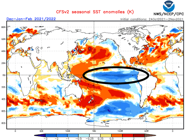
The effects of La Nina are almost global. The Pacific Ocean is roughly 32% of the surface area of the globe, more than all landmasses combined. It touches every continent but Europe and Africa. So, worldwide effects are to be expected.
In general, the effects on the U.S. are a hotter and drier southern tier of the country, a colder north-central, and a wetter eastern Midwest.
P[L1] D[0x0] M[300x250] OOP[F] ADUNIT[] T[]
In South America, we typically find drier conditions in Argentina and southern Brazil being broken up by occasional frontal passages and scattered showers. That pattern is in full effect now. And in Australia, we typically see better rainfall chances and amounts as warmer ocean waters off the coast increase showers across this portion of the Pacific. That has just crept up during the last couple of weeks as well.
So, La Nina has already been having an influence on global weather, even if it was not officially declared by both of the major governing bodies that monitor these conditions.
That may be why the Southern Plains has been on a dry spell during the last few weeks. Drought has been increasing across the region, but specifically in the western half, from eastern Colorado and western Kansas down through West Texas. Winter wheat conditions have been on the decline because of the dryness, with only 44% of the crop rated good to excellent on the USDA's latest Crop Progress Report. That is the second-lowest rating at this time of year since 2010, according to DTN Lead Analyst Todd Hultman.
A front moving through the country this week is not going to help out wheat plants in that region. Showers are expected to develop from eastern Oklahoma and Texas up through the eastern Midwest, however, which would help some of those drier areas in the southeastern Plains. But conditions are continuing to get worse as we head to the last month of the year. With La Nina having a drying effect across the region, there is real concern for the crop going into next year.
Conversely, the already moist soils in the eastern Midwest may be too wet come this spring should the forecast ring true. It may take some time for soils to dry out before planting can get done, making planting windows a bit tighter than the last couple of springs.
And drought still ongoing over the north-central U.S. is likely to continue through the winter and into spring. While planting windows may be longer, lingering drought would increase importance of spring and summer rains for good crops next year.
You can read more about the impacts of the expected drought from DTN's Bryce Anderson here: https://www.dtnpf.com/….
**
Get a full rundown on the 2022 outlook for weather affecting U.S. and international crop areas during the DTN Ag Summit, Dec. 5-7, in Chicago. Visit www.dtn.com/agsummit for more details about the summit and to register. Register before Nov. 26 for the early bird rate.
John Baranick can be reached at john.baranick@dtn.com
(c) Copyright 2021 DTN, LLC. All rights reserved.