
Case IH On-the-Go Smart Tillage Venture
Case IH, EarthOptics Pursue Soil Mapping Tech for Better Crop, Carbon Management
CNH Industrial announced earlier this week that it has joined other investors in a $27.6 million Series B funding round of innovative tech startup EarthOptics.
EarthOptics is a soil data measurement and mapping company. It is developing technologies that create accurate, real-time data maps -- including compaction, carbon, moisture and nutrients -- to give operators new soil health and soil structure intelligence about their farms -- data that may help farmers make informed decisions about when and where to till and to accurately map soil carbon. EarthOptics promises "high-precision data about the condition of your fields with fewer soil samples and less disruption to growing operations at a significantly lower cost."
CNH believes its investment will allow its Case IH brand to accelerate its development of autonomous tillage systems that both reduce inputs and help farmers implement practices that directly impact soil carbon levels.
To put a little more meat on the bones of the announcement, DTN/Progressive Farmer spoke with Monte Weller, Case IH global product line director. Here is what he said.
**
DTN/PF: Explain what EarthOptics brings, generally, to CNH Industrial and Case IH, specifically.
Weller: Case IH has been working to bring smarter implements, smarter iron (to farmers). If you step back and look at precision farming technologies, there is not a lot of work out in the world of soil management tillage in precision farming. We are building our smart iron platforms, (that with) better agronomic insights, we can know how to better set up a smart tillage tool. Can we identify the compaction layers in the soil? EarthOptics brings a unique technology twist with ground-penetrating radar. And what we're really looking at is, in real-time, finding the compaction layers in the soil. We know there's high variability in any field, many different soil types, different tillage practices that all go on. But if we can refine (tillage), there is tremendous value in that optimization, in fuel savings, cost savings and yield improvements by managing soil health.
**
DTN/PF: This is technology that would blend into Case IH's Soil Command seedbed sensing technology?
P[L1] D[0x0] M[300x250] OOP[F] ADUNIT[] T[]
Weller: I anticipated you would ask that, and I hoped you would. Bringing the EarthOptics ground-penetrating radar sensing technology onboard, changing the tillage implement on the go based upon EarthOptics readings, (based on levels) of compaction or where the compaction is, (would) all be done seamlessly through Soil Command.
**
DTN/PF: What does EarthOptics bring to the table? Is it strictly a soil compaction tool? In the press release about this, CNH investment talks also about identifying and preserving soil carbon levels.
Weller: There are several aspects of what EarthOptics brings to the table. One is ground-penetrating radar. The other is measurement of soil carbon. I'd say (one of) the spinoffs of this sensing technology is really automating sensing capabilities for carbon sequestration and carbon measurements. And that will be another branch of what this technology brings for measuring, monitoring and reporting.
**
DTN/PF: Is this an on-the-go technology that can be done in the field, or is this a soil sampling technology?
Weller: Today, it's a methodology (for) ground-truthing by soil testing. In the future, this will be automated to really be an on-the-go type of sensing technology. EarthOptics is a startup, and we are in the early stages developing sensing technologies for commercialization.
**
DTN/PF: Draw a picture of what this would look like in the field.
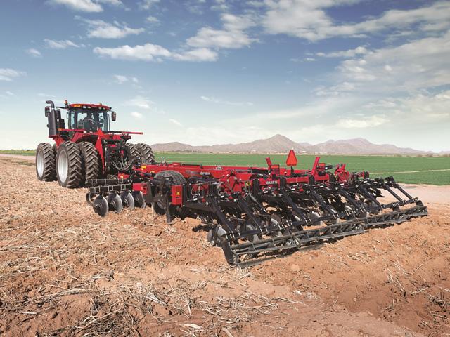
Weller: Imagine having a sensor on the front of a tractor, out where the tractor weights are set today. And then imagine that tractor hooked to a Case IH 875 Combo Ripper. That's a well-known fall tillage tool that can rip the soil down to 16 inches deep. So, this ground-penetrating radar sensor that's on the front of that tractor can basically read the soil profile out in front of that tractor and know where the compaction layers are anywhere from the top 2 inches of soil down to 16 inches of the soil, and automatically change on the go the depth of that ripper going through the field. Instead of turning the soil black with the ripper, that operator has less wear and tear, doesn't have to waste power and waste fuel. The soil can be managed anywhere from not even engaging the soil to all the way down to 16 inches. That's the vision, and this is all done real-time, or a prescription can be loaded into the cab of the tractor with an AFS Pro 1200 display and be executed.
**
DTN/PF: I'd imagine, then, by not ripping an entire field, you are enhancing the ability of the soil to contain or hold the carbon benefit?
Weller: Absolutely. It is managing the crop or managing the residue or managing the soil erosion. It's a new way of thinking, of managing carbon and imagining the crop being grown or (the crop that) will be grown. There is a lot to be learned in this arena, which, as you are probably aware, is fast changing on us -- especially with carbon, carbon sequestration and carbon credits, as well as monitoring, managing, and mapping and recording it.
Dan Miller can be reached at dan.miller@dtn.com
Follow him on Twitter @DMillerPF
(c) Copyright 2023 DTN, LLC. All rights reserved.