

Cash Market Moves
Will It Be Deja Vu on the Lower Mississippi River This Fall?
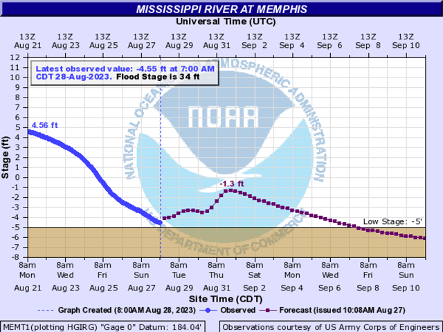
The memory of last fall still lingers of when the Lower Mississippi River dropped to a record low at Memphis, Tennessee, stalling barge traffic right in the middle of harvest. Now, one year later, levels at Memphis are stuck below zero gauge and causing concern of a repeat of 2022.
Besides Memphis, the Mississippi River at St. Louis is at minus 1.02 feet on Aug. 28 and is forecast to reach minus 3.3 feet by Sept. 1. At these low levels, safety restrictions are now in place.
For now, current levels for the river shippers means that barge drafts have been cut to 10 feet, 6 inches and, in some cases, tow sizes are reduced. Shippers will have to load less product but pay the same freight for a full barge and if there is a reduction in tow size, less product gets to destination via one shipment.
Barge freight has started to rise with September numbers bid at 775% of tariff bid against offers of 800% and October is bid 800% against offers of 850%. To calculate the barge rate in dollars per ton, multiply the rate quote by the benchmark and divide by 100. Each location has a different base rate (from 1976). As an example, an 800% tariff for St. Louis barge grain would equal 8.00 times the benchmark rate of $3.99, or $31.92 per ton. See all tariff benchmark rates here: https://www.ams.usda.gov/….
P[L1] D[0x0] M[300x250] OOP[F] ADUNIT[] T[]
The higher barge freight then causes basis to weaken which, in turn, financially affects the farmer who hauls grain to a river terminal. Besides the higher barge freight causing basis to weaken, corn and soybean basis has been under pressure from the southern harvest and the likelihood of an early harvest in the Midwest.
Don't forget a prolonged low water event could also slow or stall barges needing to move upriver with fall fertilizer.
As for good news coming out of the latest weather forecast, don't hold your breath. DTN Ag Meteorologist John Baranick noted in his Aug. 27 forecast that "There is a ridge in the West with a strong portion in Western Canada, and a trough in the East. Another trough is off the West Coast. All features will move east this week, but a portion of the western trough will remain pinched off across the West. The ridge will pump up again over the middle of the country by the weekend and this pattern will largely continue through next week. Tropical Storm/Hurricane Idalia will move through the Southeast in the middle of this week as well.
"The U.S. and European models are similar. I will use a blend. For the outlook period, temperatures will be above normal across most of the country outside of the West, which looks to continue through next week. Temperatures may be extremely high again. Outside of some showers in the northwestern Plains and Canadian Prairies, or a tropical storm in the Gulf of Mexico, very little precipitation is forecast."
In trying to end with a little good news, know that the dredges -- the heroes of last year's extreme low water conditions -- are already hard at work. The Dredge Jadwin was working at LMR Mile 545 last week with planned rolling 24-hour closures, causing a slowdown in barges through that area and the Dredge Hurley was at LMR mile 653. These dredges will move around as needed to troublesome spots in order to keep the channel open.
DTN story on dredging: https://www.dtnpf.com/…
Mississippi River at Memphis hydrograph: https://water.weather.gov/…
Mississippi River at St. Louis hydrograph: https://water.weather.gov/…
Mary Kennedy can be reached at mary.kennedy@dtn.com
Follow her on X, formerly known as Twitter, @MaryCKenn
(c) Copyright 2023 DTN, LLC. All rights reserved.