

South America Calling
Is Argentina's Corn and Soybean Production Beyond Saving?
Anything and everything that can go wrong for Argentina's corn and soybean crops has gone wrong this season. It can always be worse, I suppose, but sustained heatwaves, drought, and even mid-summer frosts have combined to create abysmal growing conditions for the world's historically fourth-largest producer of corn and third-largest producer of soybeans.
Therefore, production estimates of both public and private entities continue to trend downward. The USDA just released, in its March World Agriculture Supply and Demand Estimates (WASDE), a significant drop in both corn and soybean production out of the country. The estimate lowered corn production from 47 million metric tons (mmt) to 40 mmt, and soybean production from 41 mmt to 33 mmt from February to March. Private estimates are lower for both. The significant drops from production from last year's estimates from USDA of 49.5 mmt of corn and 43.9 mmt of soybeans underscore just how bad the weather has been in the country. Last year saw significant heat and dryness concerns as well, but nothing compared to what has transpired so far this year.
Planting was delayed significantly due to the early drought concerns and more of the crop was shifted out of the first-phase corn into soybeans or second-phase corn. Some rains did occur throughout the year, but not enough to eliminate drought. Estimates from DTN peg the Pampas region, Argentina's primary growing area, as having anywhere from 20-60% of normal precipitation during the last 90 days with little exception. That generally means anywhere from 75 to 250 millimeters (about 3 to 10 inches) less precipitation than normal. At the same time, the country has seen temperatures regularly push up to 40 Celsius (104 Fahrenheit), sometimes for long stretches of time. Soil moisture estimates from satellite suggest that conditions are among the worst in the last 50 years.
P[L1] D[0x0] M[300x250] OOP[F] ADUNIT[] T[]
The question is whether or not the corn and soybean crop are beyond saving. With most of the first-phase corn planting maturing and the harvest starting soon, it is unlikely that future precipitation or cooler temperatures will help. However, with a significant portion of second-phase corn in still in reproductive and early fill stages, and soybeans starting to fill pods, rainfall during the next few weeks could have some impact.
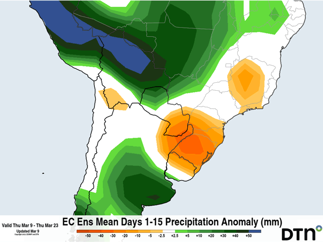
Some showers are forecast on the far southern end of the Pampas through Mar. 14 before spreading farther north through the rest of the territory. Models are suggesting a few waves of precipitation that might bring some significant amounts through about Mar. 23 or so. Rainfall amounts of 40 to 100 mm (about 1.5 to 4 inches) are forecast for the area, with some areas seeing more and some seeing less. But it does point to the possibility of a good stretch of rainfall.
We have seen a 10-day stretch of good weather before, but it only had a small impact on crop conditions back in January. Further dryness and temperature extremes that followed destroyed any positive momentum that the crop was experiencing. The forecast for April offers a return to dryness with continued high temperatures, a rather unfortunate combination.
That last feature may be the most concerning for the remainder of the season. High temperatures since late last week have been up toward the 40 C mark and are likely to only be interrupted during rain. That continues through Mar. 18-19, when a stronger cold front is forecast to bring temperatures down again. But a long stretch of heat increases moisture requirements for a crop that is severely damaged by heat and drought this season.
Will the rains come as forecast? And will that matter to the rest of the crop? Those are a couple of good questions we will not know the answer to for a few weeks.
To find more international weather conditions and your local forecast from DTN, visit https://www.dtnpf.com/….
John Baranick can be reached at john.baranick@dtn.com
(c) Copyright 2023 DTN, LLC. All rights reserved.

Comments
To comment, please Log In or Join our Community .