

Ag Weather Forum
Wetness Returns to Southwestern Canadian Prairies
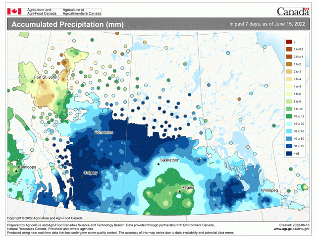
The storm system that is finally leaving on June 16 has produced significant and widespread precipitation across the majority of the region. According to Agriculture and Agri-Food Canada, over the last seven days ending June 15, only an area around south-central Saskatchewan and the Peace region of Alberta have reported less than 30 millimeters (1.2 inches) of rain. In fact, most of these other areas have received more than 50 millimeters (around two inches) in that period. While some portions of south-central Saskatchewan needed heavy rainfall and did not receive it from this system, the majority of southern Alberta and far southwest Saskatchewan had their prayers answered.
Seeding has all but been completed in this region and the drought that has ensued has had a large reduction from this one storm. According to the latest crop report issued by Saskatchewan on June 16, rainfall was significant across the west-central and northwest portions of the province, increasing topsoil moisture for developing crops and pastures by significant amounts. That data was recorded through June 13, in the midst of the week's rainstorm. The report noted that rain was not enough and more was needed in these western regions. That needed rain came over the following three days, essentially doubling the rainfall amounts in the report.
Alberta's report has not been issued for the week but will include most of the rainfall from the week when it is released on June 17, covering precipitation through June 14. That report is expected to show further increases in topsoil moisture across southern areas of the province, building upon rainfall in the previous week that had brought soil moisture much closer to normal for this time of year. An issue in this province has been a reversal from drought to flooding. Over the last two weeks, rainfall in the southern half of the growing region of Alberta has eclipsed 65 millimeters (mm) (2.56 inches). Due to upslope flow into the Rockies, amounts in the mountains are significantly higher. The fear is the precipitation falling on the mountain snowpack, which is heavier than normal, could lead to some flooding from rivers draining into the Plains.
P[L1] D[0x0] M[300x250] OOP[F] ADUNIT[] T[]
Such a drastic turnaround in soil moisture is certainly welcome in the area. Still, the rains are not enough to make a good crop this early in the year. More will be needed throughout the remaining growing season. Those in these areas will be thankful for the weather pattern that continues to be active in the region.
The same active pattern that had been in place across the central U.S. in May and early June has shifted northward. Storm systems are now flowing through the region instead of to the south. The track brings low pressure centers right through the heart of the region, where rainfall is most widespread. That will continue to be the case. The storm system this week may have been a rather strong one, but it is the first of more to come.
A ridge of high pressure has built into the southern U.S., pushing the jet stream northward into Canada. Troughs of low pressure have moved into western Canada and travelled across the northern edge of that ridge right through the Prairies. As they do, they bring their storm systems and subsequent rainfall with them. With that ridge holding firm over the next several weeks and likely well into July, the Canadian Prairies are set to remain active with storm systems moving through.
Another one of these troughs of low pressure is moving into western Canada on June 16 and will pass through the Prairies early next week. Showers and thunderstorms will move into portions of the Prairies prior to that and several days of scattered precipitation are expected with it. Though the trough will follow a similar path as the previous one, precipitation amounts are not expected to be nearly as widespread or heavy. Thunderstorms can produce heavier amounts in localized areas, but, overall, the region is looking at widespread scattered rainfall, but not with excessive amounts. As long as flooding does not occur, that seed in the ground should find good conditions for growth.
On the flip-side, Manitoba and far eastern Saskatchewan have been too wet. This has led to slower progress for seeding and has forced producers to change their tactics and crop intentions. More of these areas may be unseeded this year because of the shortened growing season this year. The active pattern will only exacerbate that potential.
To find more international weather conditions and your local forecast from DTN, head over to https://www.dtnpf.com/…
John Baranick can be reached at john.baranick@dtn.com
(c) Copyright 2022 DTN, LLC. All rights reserved.

Comments
To comment, please Log In or Join our Community .