

Ag Weather Forum
Heavy Rain Delays Corn and Soy Harvest, Colder Air Expected Next Week
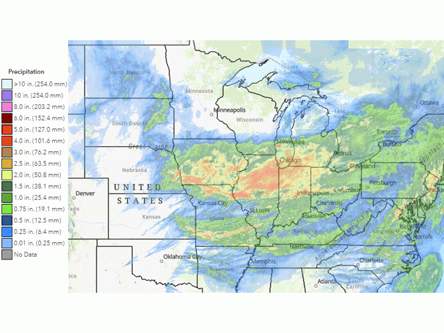
A strong system developed in the eastern Plains on Friday and brought rounds of widespread moderate to heavy rain across a good portion of the Corn Belt through Monday before it exited eastward.
This system dropped over 1 inch of rain from far eastern Nebraska and Kansas almost straight eastward through the Corn Belt and into the Mid-Atlantic. A large area of amounts in the 2- to 4-inch range and locally a bit heavier was noted from southern Iowa and northern Missouri east through southern Michigan and northwest Ohio.
The rain was a large benefit for those whose operations were completed and were in drought, particularly in Iowa and northern Illinois. But much of this region was still behind average pace for corn harvest and still with significant portions of the crop in the field such as Indiana (43% remaining), Michigan (53% remaining), Ohio (59% remaining), and Pennsylvania (63% remaining). The soybean harvest was farther behind the average in these states, including in Illinois, though the harvest for soybeans is farther along than for corn.
P[L1] D[0x0] M[300x250] OOP[F] ADUNIT[] T[]
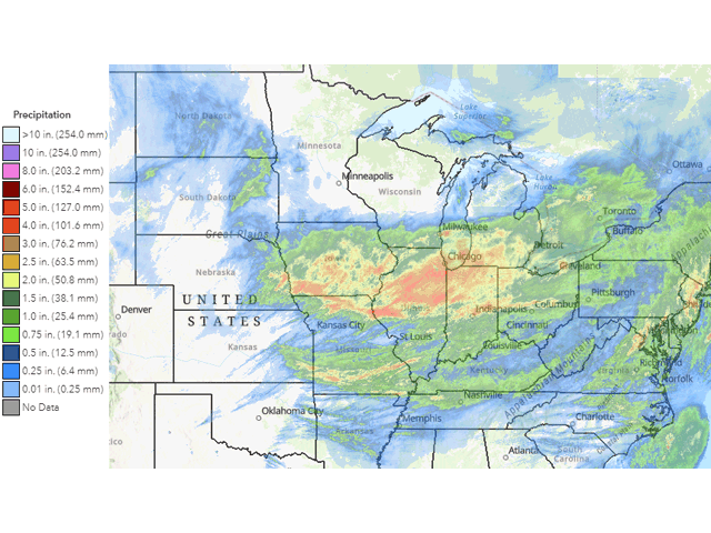
There will not be much relief for these areas this week. A system that has already brought flooding rainfall to California is pushing through the Rockies on Oct. 26. It will emerge in the Plains and produce severe weather from Kansas down into Texas before moving into the central and Eastern Corn Belt Oct. 27-28 and eventually exit to the east Oct. 30.
Rainfall amounts from the eastern Plains into the western Midwest will be on the order of 1-to-3 inches for most of these areas. While showers will not be as heavy as the system pivots eastward through the rest of the Corn Belt, rainfall amounts could add up to another inch on top of what we saw during the last several days.
And the almost daily nature of the showers for two or three days will keep producers out of the fields likely until next week for many of these areas. We should see some much slower progress in next week's Crop Progress Report from the USDA, and could see some quality issues emerge as well.
While the remaining corn and soybean harvest will have the largest focus, the impact to winter wheat is a little more complicated. Hard red winter wheat areas in the Plains are set to get some thunderstorms, which could be severe on the evening and overnight of Oct. 26-27. But the rains are going to miss a lot of the southwestern Plains from western Kansas down through west Texas.
Kansas is still doing alright in terms of soil moisture, which is reflected in the 63% good-to-excellent rating for wheat in the latest USDA Crop Progress Report. But it is dry in west Texas. Rainfall that misses here is not going to be good for establishment as temperatures remain mild even though average temperatures are falling now.
Soft red winter wheat areas in the Midwest saw heavy rainfall that delayed planting and progress thus far has been slower than normal. Illinois, Indiana, Michigan and Ohio are all behind the average pace and still have between 25% and 34% left to plant. The delays could be extended further into November and that will leave these plants with only a short period to produce good root zones before winter weather settles in.
Speaking of winter's temperatures, it appears the first shot of colder air will work into the middle of the country this weekend and into next week. Highs in the 30s and 40s Fahrenheit in the North-Central U.S. are expected to follow a cold front that should sweep through much of the country, with 40s and 50s from the Central and Southern Plains into the Mid-Atlantic. This shot of cold air may be brief, but is a sign that November could end up with below-normal temperatures for the month, as DTN is forecasting. Temperatures below normal would likely force winter wheat into dormancy a bit quicker, leaving the window for root development shorter. Should drought start off the 2022 spring in some of these areas, wheat could see some challenges.
John Baranick can be reached at john.baranick@dtn.com
(c) Copyright 2021 DTN, LLC. All rights reserved.
Comments
To comment, please Log In or Join our Community .