

South America Calling
Another Heatwave for Argentina
It is becoming harder and harder to describe the same reality over and over again -- the weather situation in Argentina is far from ideal and conditions are not improving. True, cold fronts come through with some regularity, approximately once per week with scattered showers. But between the fronts, temperatures rise above normal and sap any available soil moisture. Another heatwave is coming to Argentina and crop conditions continue to suffer across the country.
As of Jan. 5, the Buenos Aires Grain Exchange reports that excellent ratings on soybeans sits at just 8%. That is down another two percentage points from last week, and compares to 50% from the same time last year.
The same report shows a similar situation with corn. In total, just 13% of corn in the country's corn is rated as excellent, down a matching two percentage points from last week, and down from 41% last year.
P[L1] D[0x0] M[300x250] OOP[F] ADUNIT[] T[]
What is more telling is the poor rating, which have risen to 38% in soybeans and 32% in corn. Both of these ratings are up from the last week, and well ahead of last season, where it was just 13% in soybeans and 20% in corn. Both crops had production issues last year, but this year seems to be worse.
The recent rains have just not been good enough to combat the early spring drought and dryness, or subdue the effects of the heat. According to satellite data as of Jan. 1, soil moisture across the entire country's growing regions is well-below normal, including some of the driest soils on record across the Pampas region, Argentina's primary growing area for corn and soybeans.
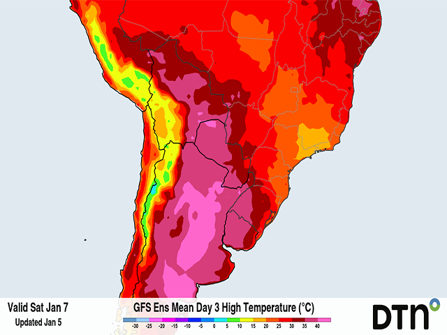
And the situation is not getting any better. Temperatures will be rising during the next couple of days, pushing close to 40 degrees Celsius (more than 100 degrees Fahrenheit) in many areas from Jan. 6 to Jan 10. Five days of temperatures this high will continue to significantly stress crops and dry up any available soil moisture still left.
The heatwave will come to an end with the passage of a cold front between Jan. 10-11. The front will have some showers with it, but models are insisting that the showers will be spotty and weak, with most areas receiving less than 10 millimeters (0.4 inches). It will remain dry until this front passes through, and there is only a small chance that showers develop behind the front with another disturbance moving through Jan. 12-13, but models do not agree that this will occur or how heavy any showers would be.
After this disturbance, rain again looks to be scant. Longer-range models produce another front a week later, and another about a week after that. The spread-out nature of the showers continues to lead to poor growing conditions as the first-phase corn crop goes deeper into pollination and while the second-phase corn and soybeans continue to go through their development after delayed planting.
To find more international weather conditions and your local forecast from DTN, visit https://www.dtnpf.com/….
John Baranick can be reached at john.baranick@dtn.com
(c) Copyright 2023 DTN, LLC. All rights reserved.