

Ag Weather Forum
Two Potent Features

Soybean harvest is moving quickly. Overall, 38% of the soybean crop has been harvested, an 18-point increase since last week, which is outpacing the five-year average by 10 points. Large gains were made through much of the Corn Belt with some slowdowns in Wisconsin, Michigan and Ohio due to showers.
Corn harvest progressed as well, increasing by 10 percentage points for the week. Notable gains occurred across much of the beltline of the U.S. with a 15-point gain in Kansas, a 13-point gain in Illinois and Iowa, an 11-point gain in Missouri and a 10-point gain in Indiana. It was a bit slower in the northwest, perhaps due to wind, and in the east due to showers.
P[L1] D[0x0] M[300x250] OOP[F] ADUNIT[] T[]
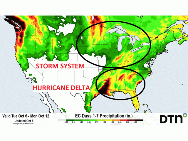
Warm and dry weather will continue to spread across the major growing areas in the north this week, with little in the way to hinder harvest progress. However, the pattern shows a big change in the seven- to 10-day period. A strong storm system moving from the Plains toward Ontario, Canada, early next week will bring colder temperatures and moderate to locally heavy rain to the northern Midwest. Very little rain is likely in the Southern Plains, with intensifying drought. Almost all of Kansas is now in some phase of drought, according to the U.S. Drought Monitor.
In the South, Hurricane Delta is expected to make landfall along the central Gulf Coast Friday night or Saturday morning. The system is projected to spread heavy rainfall across the Delta and moderate rain over the Southeast Thursday through the weekend. Areas that have been hit with heavy rain from previous storms Hurricane Sally and Tropical Storm Beta may have more rain, causing damage to cotton and peanuts, along with disruptions to row-crop harvest. More than half of this year's soybean crop remains in the Delta with very little cotton picked outside of Louisiana and Mississippi.
Moisture from this system is likely to remain south of the Ohio River. However, should a slower track take shape, the Eastern Corn Belt could see more moderate rainfall early next week. This would cause delays to the ongoing harvest but increase topsoil moisture for developing winter wheat.
La Nina continues to develop in the equatorial Pacific and is forecast to persist through the upcoming winter. Typically, La Nina produces a colder and snowier northern tier of the country as well as a warmer and drier southern tier. This would put winter wheat in the Southern Plains under continued stress. In northern areas, winter storms could be stressful for livestock and transportation. Pacific Ocean sea surface temperatures are in the range of 1.0 to 2.5 degrees Celsius below normal. In the atmosphere, the Australia Southern Oscillation Index (SOI) has a 30-day value of plus 9.92 and a 90-day value of plus 8.18 as of Tuesday, Oct. 6. Both readings are above the La Nina threshold value of plus 8.0.
John Baranick can be reached at john.baranick@dtn.com
© (c) Copyright 2020 DTN, LLC. All rights reserved.
Comments
To comment, please Log In or Join our Community .